Claix geodata
Claix (Auvergne-Rhône-Alpes) is a populated place; located in France in Europe/Paris (GMT+2) time zone. With population of 8,127 people, there are 1189 cities with bigger population in this country. Compared to other cities in France, 78.3% of cities are located further ↑North; 84.2% of cities are located further ←West and 76.9% of cities have lower elevation than Claix. Note1
Administrative division(s):
- Level 1: Auvergne-Rhône-Alpes
- Level 2: Département de l'Isère
- Level 3: Arrondissement de Grenoble
- Level 4: Claix


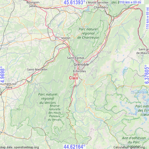
Claix GPS coordinates[2]
45° 7' 11.784" North, 5° 40' 22.512" East
| Map corner | latitude | longitude |
|---|---|---|
| Upper-left | 45.61393°, | 4.9698° |
| Center: | 45.11994°, | 5.67292° |
| Lower-right: | 44.62164°, | 6.37605° |
| Map W x H: | 110.3×110.3 km | = 68.5×68.5mi |
| max Lat: | 51.07786° ⇑78.3% North |
| Claix: | 45.11994° |
| min Lat: | ⇓21.7% South 41.3874° |
| min Long | Claix | max Long |
| -5.08615° | 5.67292° | 9.52242° |
| W 84.2%⇐ | ⇒15.8% E |
Elevation
Elevation of Claix is 263 m = 863 ft, and this is 69.3 m = 227 ft above average elevation for this country.
| Max E: |
2333 m = 7654 ft | 23.1% |
| Claix | 263 m 863 ft | |
| Avg. | 193.7 m = 635 ft | |
Min E: |
-1 m = -3 ft | 76.9% |
See also: France elevation on elevation.city.
Geographical zone
Claix is located in North temperate zone (between Tropic of Cancer and the Arctic Circle). Distance of this North polar circle is 2384.3 km =1481.5 mi to North.| Distance of | km | miles | from Claix |
|---|---|---|---|
| North Pole | 4990.2 | 3100.8 | to North |
| Arctic Circle | 2384.3 | 1481.5 | to North |
| Tropic Cancer | 2410.9 | 1498.1 | to South |
| Equator | 5016.9 | 3117.4 | to South |


Nearby cities:
15 places around Claix: (largest is in red/bold)
• Allières-et-Risset
2.3 km =1.4 mi,  167°
167°
• Bresson
6.2 km =3.9 mi,  71°
71°
• Champ-sur-Drac
7.3 km =4.5 mi,  140°
140°
• Champagnier
4.4 km =2.7 mi,  102°
102°
• Eybens
6.8 km =4.2 mi,  62°
62°
• Grenoble
7.3 km =4.5 mi,  26°
26°
• Jarrie
6.8 km =4.2 mi,  92°
92°
• Lans-en-Vercors
6.9 km =4.3 mi,  277°
277°
• Le Pont-de-Claix
2 km =1.2 mi,  79°
79°
• Saint-Nizier-du-Moucherotte
6.6 km =4.1 mi,  329°
329°
• Saint-Paul-de-Varces
5.9 km =3.7 mi,  204°
204°
• Seyssinet-Pariset
6.5 km =4 mi,  14°
14°
• Seyssins
4.8 km =3 mi, 12°
• Vif
7 km =4.3 mi,  180°
180°
• Échirolles
4.4 km =2.7 mi,  48°
48°
Sources, notices
• [Note1] Compared only with cities in France existing in our database
• [Src1] Map data: © OpenStreetMap contributors (CC-BY-SA)
• [Src2] Other city data from geonames.org with taken over terms of usage.
• [Src3] Geographical zone / Annual Mean Temperature by Robert A. Rohde @ Wikipedia
