Valentine geodata
Valentine (Occitanie) is a populated place; located in France in Europe/Paris (GMT+2) time zone. With population of 840 people, there are 10186 cities with bigger population in this country. Compared to other cities in France, 98% of cities are located further ↑North; 71.4% of cities are located further →East and 86.5% of cities have lower elevation than Valentine. Note1
Administrative division(s):
- Level 1: Occitanie
- Level 2: Haute-Garonne
- Level 3: Arrondissement de Saint-Gaudens
- Level 4: Valentine


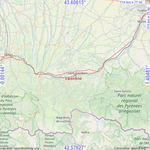
Valentine GPS coordinates[2]
43° 5' 41.496" North, 0° 42' 6.048" East
| Map corner | latitude | longitude |
|---|---|---|
| Upper-left | 43.60615°, | -0.00144° |
| Center: | 43.09486°, | 0.70168° |
| Lower-right: | 42.57927°, | 1.40481° |
| Map W x H: | 114.2×114.2 km | = 71×71mi |
| max Lat: | 51.07786° ⇑98% North |
| Valentine: | 43.09486° |
| min Lat: | ⇓2% South 41.3874° |
| min Long | Valentine | max Long |
| -5.08615° | 0.70168° | 9.52242° |
| W 28.6%⇐ | ⇒71.4% E |
Elevation
Elevation of Valentine is 367 m = 1204 ft, and this is 173.3 m = 569 ft above average elevation for this country.
| Max E: |
2333 m = 7654 ft | 13.5% |
| Valentine | 367 m 1204 ft | |
| Avg. | 193.7 m = 635 ft | |
Min E: |
-1 m = -3 ft | 86.5% |
See also: France elevation on elevation.city.
Geographical zone
Valentine is located in North temperate zone (between Tropic of Cancer and the Arctic Circle). Distance of this Northern Tropic circle is 2185.8 km =1358.2 mi to South.| Distance of | km | miles | from Valentine |
|---|---|---|---|
| North Pole | 5215.4 | 3240.7 | to North |
| Arctic Circle | 2609.5 | 1621.5 | to North |
| Tropic Cancer | 2185.8 | 1358.2 | to South |
| Equator | 4791.7 | 2977.4 | to South |


Nearby cities:
15 places around Valentine: (largest is in red/bold)
• Ausson
8.8 km =5.5 mi,  260°
260°
• Clarac
6.2 km =3.9 mi,  271°
271°
• Estancarbon
6.9 km =4.3 mi,  80°
80°
• Gourdan-Polignan
10.6 km =6.6 mi, 255°
• Labarthe-Inard
11 km =6.8 mi, 82°
• Labarthe-Rivière
2.9 km =1.8 mi,  237°
237°
• Landorthe
7.9 km =4.9 mi,  59°
59°
• Loures-Barousse
11 km =6.8 mi,  224°
224°
• Miramont-de-Comminges
3.7 km =2.3 mi,  90°
90°
• Pointis-Inard
9.1 km =5.7 mi,  96°
96°
• Pointis-de-Rivière
7 km =4.3 mi, 263°
• Ponlat-Taillebourg
8.4 km =5.2 mi,  281°
281°
• Saint-Gaudens
2.3 km =1.4 mi,  50°
50°
• Soueich
8.4 km =5.2 mi,  130°
130°
• Villeneuve-de-Rivière
4.8 km =3 mi,  320°
320°
Sources, notices
• [Note1] Compared only with cities in France existing in our database
• [Src1] Map data: © OpenStreetMap contributors (CC-BY-SA)
• [Src2] Other city data from geonames.org with taken over terms of usage.
• [Src3] Geographical zone / Annual Mean Temperature by Robert A. Rohde @ Wikipedia
