Vacheresse geodata
Vacheresse (Auvergne-Rhône-Alpes) is a populated place; located in France in Europe/Paris (GMT+2) time zone. With population of 670 people, there are 12215 cities with bigger population in this country. Compared to other cities in France, 62% of cities are located further ↑North; 92.9% of cities are located further ←West and 99.1% of cities have lower elevation than Vacheresse. Note1
Administrative division(s):
- Level 1: Auvergne-Rhône-Alpes
- Level 2: Haute-Savoie
- Level 3: Arrondissement de Thonon-les-Bains
- Level 4: Vacheresse


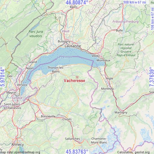
Vacheresse GPS coordinates[2]
46° 19' 31.224" North, 6° 40' 23.736" East
| Map corner | latitude | longitude |
|---|---|---|
| Upper-left | 46.80874°, | 5.97014° |
| Center: | 46.32534°, | 6.67326° |
| Lower-right: | 45.83763°, | 7.37639° |
| Map W x H: | 108×108 km | = 67.1×67.1mi |
| max Lat: | 51.07786° ⇑62% North |
| Vacheresse: | 46.32534° |
| min Lat: | ⇓38% South 41.3874° |
| min Long | Vacheresse | max Long |
| -5.08615° | 6.67326° | 9.52242° |
| W 92.9%⇐ | ⇒7.1% E |
Elevation
Elevation of Vacheresse is 1002 m = 3287 ft, and this is 808.3 m = 2652 ft above average elevation for this country.
| Max E: |
2333 m = 7654 ft | 0.90000000000001% |
| Vacheresse | 1002 m 3287 ft | |
| Avg. | 193.7 m = 635 ft | |
Min E: |
-1 m = -3 ft | 99.1% |
See also: France elevation on elevation.city.
Geographical zone
Vacheresse is located in North temperate zone (between Tropic of Cancer and the Arctic Circle). Distance of this North polar circle is 2250.3 km =1398.3 mi to North.| Distance of | km | miles | from Vacheresse |
|---|---|---|---|
| North Pole | 4856.2 | 3017.5 | to North |
| Arctic Circle | 2250.3 | 1398.3 | to North |
| Tropic Cancer | 2545 | 1581.4 | to South |
| Equator | 5150.9 | 3200.6 | to South |


Nearby cities:
15 places around Vacheresse: (largest is in red/bold)
• Abondance
6.4 km =4 mi,  144°
144°
• Bernex
4.1 km =2.5 mi,  4°
4°
• Champanges
10.6 km =6.6 mi,  299°
299°
• Chevenoz
3.3 km =2.1 mi, 299°
• Féternes
10.2 km =6.3 mi,  289°
289°
• Larringes
9.2 km =5.7 mi, 301°
• Lugrin
8.7 km =5.4 mi,  349°
349°
• Maxilly-sur-Léman
8.7 km =5.4 mi,  338°
338°
• Neuvecelle
9 km =5.6 mi,  328°
328°
• Saint-Jean-d’Aulps
10.2 km =6.3 mi,  188°
188°
• Saint-Paul-en-Chablais
7.1 km =4.4 mi, 328°
• Thollon-les-Mémises
7.3 km =4.5 mi,  27°
27°
• Vailly
10.6 km =6.6 mi,  255°
255°
• Vinzier
4.9 km =3 mi, 302°
• Évian-les-Bains
10.7 km =6.6 mi,  322°
322°
Sources, notices
• [Note1] Compared only with cities in France existing in our database
• [Src1] Map data: © OpenStreetMap contributors (CC-BY-SA)
• [Src2] Other city data from geonames.org with taken over terms of usage.
• [Src3] Geographical zone / Annual Mean Temperature by Robert A. Rohde @ Wikipedia
