Lugrin geodata
Lugrin (Auvergne-Rhône-Alpes) is a populated place; located in France in Europe/Paris (GMT+2) time zone. With population of 2,164 people, there are 4437 cities with bigger population in this country. Compared to other cities in France, 61% of cities are located further ↑North; 92.7% of cities are located further ←West and 87.5% of cities have lower elevation than Lugrin. Note1
Administrative division(s):
- Level 1: Auvergne-Rhône-Alpes
- Level 2: Haute-Savoie
- Level 3: Arrondissement de Thonon-les-Bains
- Level 4: Lugrin


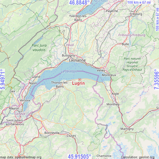
Lugrin GPS coordinates[2]
46° 24' 7.488" North, 6° 39' 10.188" East
| Map corner | latitude | longitude |
|---|---|---|
| Upper-left | 46.8848°, | 5.94971° |
| Center: | 46.40208°, | 6.65283° |
| Lower-right: | 45.91505°, | 7.35596° |
| Map W x H: | 107.8×107.8 km | = 67×67mi |
| max Lat: | 51.07786° ⇑61% North |
| Lugrin: | 46.40208° |
| min Lat: | ⇓39% South 41.3874° |
| min Long | Lugrin | max Long |
| -5.08615° | 6.65283° | 9.52242° |
| W 92.7%⇐ | ⇒7.3% E |
Elevation
Elevation of Lugrin is 381 m = 1250 ft, and this is 187.3 m = 615 ft above average elevation for this country.
| Max E: |
2333 m = 7654 ft | 12.5% |
| Lugrin | 381 m 1250 ft | |
| Avg. | 193.7 m = 635 ft | |
Min E: |
-1 m = -3 ft | 87.5% |
See also: France elevation on elevation.city.
Geographical zone
Lugrin is located in North temperate zone (between Tropic of Cancer and the Arctic Circle). Distance of this North polar circle is 2241.7 km =1392.9 mi to North.| Distance of | km | miles | from Lugrin |
|---|---|---|---|
| North Pole | 4847.6 | 3012.2 | to North |
| Arctic Circle | 2241.7 | 1392.9 | to North |
| Tropic Cancer | 2553.5 | 1586.7 | to South |
| Equator | 5159.4 | 3205.9 | to South |


Nearby cities:
15 places around Lugrin: (largest is in red/bold)
• Bernex
4.9 km =3 mi,  156°
156°
• Champanges
8.4 km =5.2 mi,  246°
246°
• Chevenoz
7 km =4.3 mi,  190°
190°
• Féternes
9.5 km =5.9 mi,  237°
237°
• Larringes
7.2 km =4.5 mi, 239°
• Marin
10.1 km =6.3 mi,  255°
255°
• Maxilly-sur-Léman
1.7 km =1.1 mi, 255°
• Neuvecelle
3.2 km =2 mi, 255°
• Publier
8.5 km =5.3 mi, 259°
• Saint-Gingolph
11 km =6.8 mi,  95°
95°
• Saint-Paul-en-Chablais
3.3 km =2.1 mi,  220°
220°
• Thollon-les-Mémises
5.3 km =3.3 mi,  113°
113°
• Vacheresse
8.7 km =5.4 mi,  169°
169°
• Vinzier
6.5 km =4 mi,  203°
203°
• Évian-les-Bains
5 km =3.1 mi,  268°
268°
Sources, notices
• [Note1] Compared only with cities in France existing in our database
• [Src1] Map data: © OpenStreetMap contributors (CC-BY-SA)
• [Src2] Other city data from geonames.org with taken over terms of usage.
• [Src3] Geographical zone / Annual Mean Temperature by Robert A. Rohde @ Wikipedia
