Troyes geodata
Troyes (Grand Est) is a seat of a second-order administrative division; located in France in Europe/Paris (GMT+2) time zone. With population of 60,785 people, there are 83 cities with bigger population in this country. Compared to other cities in France, 64.6% of cities are located further ↓South; 68.7% of cities are located further ←West and 59.1% of cities have higher elevation than Troyes. Note1
Administrative division(s):
- Level 1: Grand Est
- Level 2: Département de l'Aube
- Level 3: Arrondissement de Troyes
- Level 4: Troyes


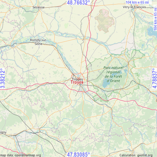
Troyes GPS coordinates[2]
48° 18' 2.628" North, 4° 5' 6.864" East
| Map corner | latitude | longitude |
|---|---|---|
| Upper-left | 48.76632°, | 3.38212° |
| Center: | 48.30073°, | 4.08524° |
| Lower-right: | 47.83085°, | 4.78837° |
| Map W x H: | 104×104 km | = 64.6×64.6mi |
| max Lat: | 51.07786° ⇑35.4% North |
| Troyes: | 48.30073° |
| min Lat: | ⇓64.6% South 41.3874° |
| min Long | Troyes | max Long |
| -5.08615° | 4.08524° | 9.52242° |
| W 68.7%⇐ | ⇒31.3% E |
Elevation
Elevation of Troyes is 105 m = 344 ft, and this is 88.7 m = 291 ft below average elevation for this country.
| Max E: |
2333 m = 7654 ft | 59.1% |
| Avg. | 193.7 m = 635 ft | |
| Troyes | 105 m = 344 ft | |
Min E: |
-1 m = -3 ft | 40.9% |
See also: Troyes elevation on elevation.city.
Geographical zone
Troyes is located in North temperate zone (between Tropic of Cancer and the Arctic Circle). Distance of this North polar circle is 2030.6 km =1261.8 mi to North.| Distance of | km | miles | from Troyes |
|---|---|---|---|
| North Pole | 4636.5 | 2881 | to North |
| Arctic Circle | 2030.6 | 1261.8 | to North |
| Tropic Cancer | 2764.6 | 1717.8 | to South |
| Equator | 5370.5 | 3337.1 | to South |


Nearby cities:
15 places around Troyes: (largest is in red/bold)
• Barberey-Saint-Sulpice
5.7 km =3.5 mi,  317°
317°
• Bréviandes
4.9 km =3 mi,  171°
171°
• Creney-près-Troyes
5.1 km =3.2 mi,  44°
44°
• La Chapelle-Saint-Luc
3.8 km =2.4 mi,  298°
298°
• La Rivière-de-Corps
5.1 km =3.2 mi,  254°
254°
• Les Noës-près-Troyes
3 km =1.9 mi,  276°
276°
• Pont-Sainte-Marie
2.1 km =1.3 mi,  19°
19°
• Rosières-près-Troyes
4.4 km =2.7 mi,  190°
190°
• Saint-André-les-Vergers
3 km =1.9 mi,  234°
234°
• Saint-Germain
6.2 km =3.9 mi,  218°
218°
• Saint-Julien-les-Villas
3.4 km =2.1 mi,  162°
162°
• Saint-Parres-aux-Tertres
2.4 km =1.5 mi,  97°
97°
• Sainte-Maure
5.5 km =3.4 mi,  339°
339°
• Sainte-Savine
2.9 km =1.8 mi,  260°
260°
• Villechétif
4.5 km =2.8 mi,  73°
73°
Sources, notices
• [Note1] Compared only with cities in France existing in our database
• [Src1] Map data: © OpenStreetMap contributors (CC-BY-SA)
• [Src2] Other city data from geonames.org with taken over terms of usage.
• [Src3] Geographical zone / Annual Mean Temperature by Robert A. Rohde @ Wikipedia
