Barberey-Saint-Sulpice geodata
Barberey-Saint-Sulpice (Grand Est) is a populated place; located in France in Europe/Paris (GMT+2) time zone. With population of 781 people, there are 10811 cities with bigger population in this country. Compared to other cities in France, 65.3% of cities are located further ↓South; 68.1% of cities are located further ←West and 62% of cities have higher elevation than Barberey-Saint-Sulpice. Note1
Administrative division(s):
- Level 1: Grand Est
- Level 2: Département de l'Aube
- Level 3: Arrondissement de Troyes
- Level 4: Barberey-Saint-Sulpice
Current local time in Barberey-Saint-Sulpice:
03:04 AM, WednesdayDifference from your time zone: hours


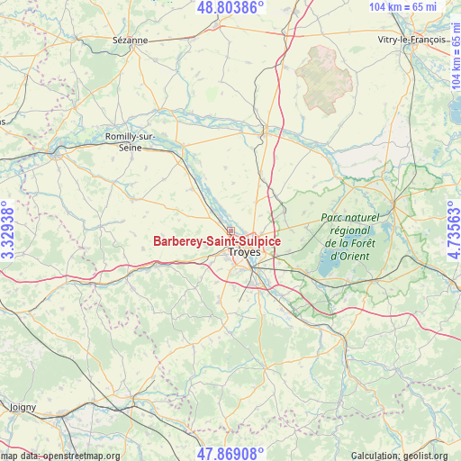
Barberey-Saint-Sulpice GPS coordinates[2]
48° 20' 18.996" North, 4° 1' 57" East
| Map corner | latitude | longitude |
|---|---|---|
| Upper-left | 48.80386°, | 3.32938° |
| Center: | 48.33861°, | 4.0325° |
| Lower-right: | 47.86908°, | 4.73563° |
| Map W x H: | 103.9×103.9 km | = 64.6×64.6mi |
| max Lat: | 51.07786° ⇑34.7% North |
| Barberey-Saint-Sulpice: | 48.33861° |
| min Lat: | ⇓65.3% South 41.3874° |
| min Long | Barberey-Saint- | max Long |
| -5.08615° | 4.0325° | 9.52242° |
| W 68.1%⇐ | ⇒31.9% E |
Elevation
Elevation of Barberey-Saint-Sulpice is 97 m = 318 ft, and this is 96.7 m = 317 ft below average elevation for this country.
| Max E: |
2333 m = 7654 ft | 62% |
| Avg. | 193.7 m = 635 ft | |
| Barberey-Saint-Sulpice | 97 m = 318 ft | |
Min E: |
-1 m = -3 ft | 38% |
See also: France elevation on elevation.city.
Geographical zone
Barberey-Saint-Sulpice is located in North temperate zone (between Tropic of Cancer and the Arctic Circle). Distance of this North polar circle is 2026.4 km =1259.1 mi to North.| Distance of | km | miles | from Barberey-Saint-Sulpice |
|---|---|---|---|
| North Pole | 4632.3 | 2878.4 | to North |
| Arctic Circle | 2026.4 | 1259.1 | to North |
| Tropic Cancer | 2768.8 | 1720.5 | to South |
| Equator | 5374.7 | 3339.7 | to South |


Nearby cities:
15 places around Barberey-Saint-Sulpice: (largest is in red/bold)
• Creney-près-Troyes
7.5 km =4.7 mi,  94°
94°
• La Chapelle-Saint-Luc
2.4 km =1.5 mi,  167°
167°
• La Rivière-de-Corps
5.7 km =3.5 mi,  189°
189°
• Les Noës-près-Troyes
4 km =2.5 mi, 166°
• Mergey
5.4 km =3.4 mi,  341°
341°
• Payns
6.4 km =4 mi,  320°
320°
• Pont-Sainte-Marie
5.1 km =3.2 mi,  116°
116°
• Saint-André-les-Vergers
6.1 km =3.8 mi, 166°
• Saint-Lyé
3.8 km =2.4 mi, 319°
• Saint-Parres-aux-Tertres
7.8 km =4.8 mi,  125°
125°
• Sainte-Maure
2.2 km =1.4 mi,  64°
64°
• Sainte-Savine
4.8 km =3 mi, 167°
• Torvilliers
8.4 km =5.2 mi,  211°
211°
• Troyes
5.7 km =3.5 mi,  137°
137°
• Villechétif
8.7 km =5.4 mi,  109°
109°
Sources, notices
• [Note1] Compared only with cities in France existing in our database
• [Src1] Map data: © OpenStreetMap contributors (CC-BY-SA)
• [Src2] Other city data from geonames.org with taken over terms of usage.
• [Src3] Geographical zone / Annual Mean Temperature by Robert A. Rohde @ Wikipedia
