Thury-Harcourt geodata
Thury-Harcourt (Normandy) is a populated place; located in France in Europe/Paris (GMT+2) time zone. With population of 1,909 people, there are 5011 cities with bigger population in this country. Compared to other cities in France, 79.3% of cities are located further ↓South; 83% of cities are located further →East and 77.8% of cities have higher elevation than Thury-Harcourt. Note1
Administrative division(s):
- Level 1: Normandy
- Level 2: Calvados
- Level 3: Arrondissement de Caen
- Level 4: Le Hom


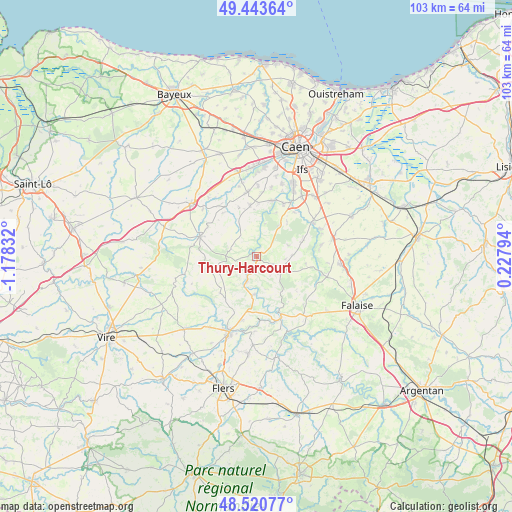
Thury-Harcourt GPS coordinates[2]
48° 59' 3.624" North, 0° 28' 30.684" West
| Map corner | latitude | longitude |
|---|---|---|
| Upper-left | 49.44364°, | -1.17832° |
| Center: | 48.98434°, | -0.47519° |
| Lower-right: | 48.52077°, | 0.22794° |
| Map W x H: | 102.6×102.6 km | = 63.8×63.8mi |
| max Lat: | 51.07786° ⇑20.7% North |
| Thury-Harcourt: | 48.98434° |
| min Lat: | ⇓79.3% South 41.3874° |
| min Long | Thury-Harcourt | max Long |
| -5.08615° | -0.47519° | 9.52242° |
| W 17%⇐ | ⇒83% E |
Elevation
Elevation of Thury-Harcourt is 60 m = 197 ft, and this is 133.7 m = 439 ft below average elevation for this country.
| Max E: |
2333 m = 7654 ft | 77.8% |
| Avg. | 193.7 m = 635 ft | |
| Thury-Harcourt | 60 m = 197 ft | |
Min E: |
-1 m = -3 ft | 22.2% |
See also: France elevation on elevation.city.
Geographical zone
Thury-Harcourt is located in North temperate zone (between Tropic of Cancer and the Arctic Circle). Distance of this North polar circle is 1954.6 km =1214.5 mi to North.| Distance of | km | miles | from Thury-Harcourt |
|---|---|---|---|
| North Pole | 4560.5 | 2833.8 | to North |
| Arctic Circle | 1954.6 | 1214.5 | to North |
| Tropic Cancer | 2840.6 | 1765.1 | to South |
| Equator | 5446.5 | 3384.3 | to South |


Nearby cities:
15 places around Thury-Harcourt: (largest is in red/bold)
• Amayé-sur-Orne
11.5 km =7.1 mi,  13°
13°
• Aunay-sur-Odon
12.1 km =7.5 mi,  289°
289°
• Barbery
9.3 km =5.8 mi,  72°
72°
• Boulon
9.2 km =5.7 mi,  40°
40°
• Bretteville-sur-Laize
12.8 km =8 mi,  58°
58°
• Cesny-Bois-Halbout
5.9 km =3.7 mi,  84°
84°
• Clinchamps-sur-Orne
11.8 km =7.3 mi,  27°
27°
• Clécy
7.5 km =4.7 mi,  182°
182°
• Fresney-le-Puceux
11.6 km =7.2 mi, 41°
• Pont-d'Ouilly
13.2 km =8.2 mi,  156°
156°
• Saint-Denis-de-Méré
13.1 km =8.1 mi,  193°
193°
• Saint-Germain-le-Vasson
12.8 km =8 mi, 81°
• Saint-Rémy
5.3 km =3.3 mi,  202°
202°
• Sainte-Honorine-du-Fay
10.5 km =6.5 mi,  352°
352°
• Évrecy
12.9 km =8 mi, 350°
Sources, notices
• [Note1] Compared only with cities in France existing in our database
• [Src1] Map data: © OpenStreetMap contributors (CC-BY-SA)
• [Src2] Other city data from geonames.org with taken over terms of usage.
• [Src3] Geographical zone / Annual Mean Temperature by Robert A. Rohde @ Wikipedia
