Barbery geodata
Barbery (Normandy) is a populated place; located in France in Europe/Paris (GMT+2) time zone. With population of 554 people, there are 14131 cities with bigger population in this country. Compared to other cities in France, 79.9% of cities are located further ↓South; 81.4% of cities are located further →East and 55.3% of cities have lower elevation than Barbery. Note1
Administrative division(s):
- Level 1: Normandy
- Level 2: Calvados
- Level 3: Arrondissement de Caen
- Level 4: Barbery


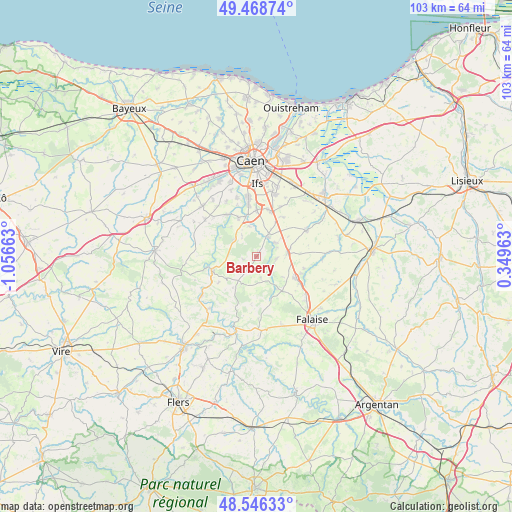
Barbery GPS coordinates[2]
49° 0' 34.812" North, 0° 21' 12.6" West
| Map corner | latitude | longitude |
|---|---|---|
| Upper-left | 49.46874°, | -1.05663° |
| Center: | 49.00967°, | -0.3535° |
| Lower-right: | 48.54633°, | 0.34963° |
| Map W x H: | 102.6×102.6 km | = 63.8×63.8mi |
| max Lat: | 51.07786° ⇑20.1% North |
| Barbery: | 49.00967° |
| min Lat: | ⇓79.9% South 41.3874° |
| min Long | Barbery | max Long |
| -5.08615° | -0.3535° | 9.52242° |
| W 18.6%⇐ | ⇒81.4% E |
Elevation
Elevation of Barbery is 151 m = 495 ft, and this is 42.7 m = 140 ft below average elevation for this country.
| Max E: |
2333 m = 7654 ft | 44.7% |
| Avg. | 193.7 m = 635 ft | |
| Barbery | 151 m = 495 ft | |
Min E: |
-1 m = -3 ft | 55.3% |
See also: France elevation on elevation.city.
Geographical zone
Barbery is located in North temperate zone (between Tropic of Cancer and the Arctic Circle). Distance of this North polar circle is 1951.8 km =1212.8 mi to North.| Distance of | km | miles | from Barbery |
|---|---|---|---|
| North Pole | 4557.7 | 2832 | to North |
| Arctic Circle | 1951.8 | 1212.8 | to North |
| Tropic Cancer | 2843.4 | 1766.8 | to South |
| Equator | 5449.4 | 3386.1 | to South |


Nearby cities:
15 places around Barbery: (largest is in red/bold)
• Boulon
5.1 km =3.2 mi,  325°
325°
• Bretteville-sur-Laize
4.4 km =2.7 mi,  26°
26°
• Cesny-Bois-Halbout
3.8 km =2.4 mi,  233°
233°
• Clinchamps-sur-Orne
8.4 km =5.2 mi,  335°
335°
• Fontenay-le-Marmion
9.3 km =5.8 mi,  0°
0°
• Fresney-le-Puceux
6 km =3.7 mi,  348°
348°
• Gouvix
4.6 km =2.9 mi,  51°
51°
• Grainville-Langannerie
5.8 km =3.6 mi,  88°
88°
• Ouilly-le-Tesson
10 km =6.2 mi,  104°
104°
• Potigny
9.3 km =5.8 mi,  118°
118°
• Rocquancourt
9.6 km =6 mi,  14°
14°
• Saint-Germain-le-Vasson
3.9 km =2.4 mi, 102°
• Soumont-Saint-Quentin
9.4 km =5.8 mi,  111°
111°
• Thury-Harcourt
9.3 km =5.8 mi,  252°
252°
• Ussy
8.5 km =5.3 mi,  143°
143°
Sources, notices
• [Note1] Compared only with cities in France existing in our database
• [Src1] Map data: © OpenStreetMap contributors (CC-BY-SA)
• [Src2] Other city data from geonames.org with taken over terms of usage.
• [Src3] Geographical zone / Annual Mean Temperature by Robert A. Rohde @ Wikipedia
