Tarbes geodata
Tarbes (Occitanie) is a seat of a second-order administrative division; located in France in Europe/Paris (GMT+2) time zone. With population of 52,106 people, there are 116 cities with bigger population in this country. Compared to other cities in France, 96.8% of cities are located further ↑North; 77.4% of cities are located further →East and 82.4% of cities have lower elevation than Tarbes. Note1
Administrative division(s):
- Level 1: Occitanie
- Level 2: Département des Hautes-Pyrénées
- Level 3: Arrondissement de Tarbes
- Level 4: Tarbes


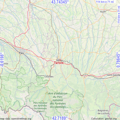
Tarbes GPS coordinates[2]
43° 13' 59.988" North, 0° 4' 59.988" East
| Map corner | latitude | longitude |
|---|---|---|
| Upper-left | 43.74345°, | -0.6198° |
| Center: | 43.23333°, | 0.08333° |
| Lower-right: | 42.7189°, | 0.78645° |
| Map W x H: | 113.9×113.9 km | = 70.8×70.8mi |
| max Lat: | 51.07786° ⇑96.8% North |
| Tarbes: | 43.23333° |
| min Lat: | ⇓3.2% South 41.3874° |
| min Long | Tarbes | max Long |
| -5.08615° | 0.08333° | 9.52242° |
| W 22.6%⇐ | ⇒77.4% E |
Elevation
Elevation of Tarbes is 315 m = 1033 ft, and this is 121.3 m = 398 ft above average elevation for this country.
| Max E: |
2333 m = 7654 ft | 17.6% |
| Tarbes | 315 m 1033 ft | |
| Avg. | 193.7 m = 635 ft | |
Min E: |
-1 m = -3 ft | 82.4% |
See also: Tarbes elevation on elevation.city.
Geographical zone
Tarbes is located in North temperate zone (between Tropic of Cancer and the Arctic Circle). Distance of this Northern Tropic circle is 2201.2 km =1367.8 mi to South.| Distance of | km | miles | from Tarbes |
|---|---|---|---|
| North Pole | 5200 | 3231.1 | to North |
| Arctic Circle | 2594.1 | 1611.9 | to North |
| Tropic Cancer | 2201.2 | 1367.8 | to South |
| Equator | 4807.1 | 2987 | to South |


Nearby cities:
15 places around Tarbes: (largest is in red/bold)
• Aureilhan
1.5 km =0.9 mi,  42°
42°
• Barbazan-Debat
5.2 km =3.2 mi,  144°
144°
• Bazet
6.6 km =4.1 mi,  348°
348°
• Bours
4.9 km =3 mi,  6°
6°
• Horgues
5 km =3.1 mi,  176°
176°
• Ibos
6.8 km =4.2 mi,  270°
270°
• Juillan
6 km =3.7 mi,  231°
231°
• Laloubère
3.3 km =2.1 mi,  194°
194°
• Momères
6.2 km =3.9 mi, 175°
• Odos
4.6 km =2.9 mi,  207°
207°
• Orleix
5.9 km =3.7 mi,  30°
30°
• Oursbelille
7 km =4.3 mi,  325°
325°
• Sarrouilles
3.6 km =2.2 mi,  97°
97°
• Soues
3.1 km =1.9 mi,  156°
156°
• Séméac
1.9 km =1.2 mi, 104°
Sources, notices
• [Note1] Compared only with cities in France existing in our database
• [Src1] Map data: © OpenStreetMap contributors (CC-BY-SA)
• [Src2] Other city data from geonames.org with taken over terms of usage.
• [Src3] Geographical zone / Annual Mean Temperature by Robert A. Rohde @ Wikipedia
