Sormonne geodata
Sormonne (Grand Est) is a populated place; located in France in Europe/Paris (GMT+2) time zone. With population of 539 people, there are 14413 cities with bigger population in this country. Compared to other cities in France, 92.3% of cities are located further ↓South; 72.5% of cities are located further ←West and 60% of cities have lower elevation than Sormonne. Note1
Administrative division(s):
- Level 1: Grand Est
- Level 2: Ardennes
- Level 3: Arrondissement de Charleville-Mézières
- Level 4: Sormonne


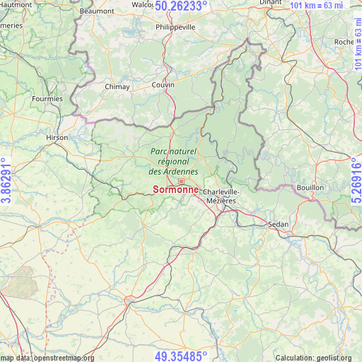
Sormonne GPS coordinates[2]
49° 48' 38.592" North, 4° 33' 57.744" East
| Map corner | latitude | longitude |
|---|---|---|
| Upper-left | 50.26233°, | 3.86291° |
| Center: | 49.81072°, | 4.56604° |
| Lower-right: | 49.35485°, | 5.26916° |
| Map W x H: | 100.9×100.9 km | = 62.7×62.7mi |
| max Lat: | 51.07786° ⇑7.7% North |
| Sormonne: | 49.81072° |
| min Lat: | ⇓92.3% South 41.3874° |
| min Long | Sormonne | max Long |
| -5.08615° | 4.56604° | 9.52242° |
| W 72.5%⇐ | ⇒27.5% E |
Elevation
Elevation of Sormonne is 170 m = 558 ft, and this is 23.7 m = 78 ft below average elevation for this country.
| Max E: |
2333 m = 7654 ft | 40% |
| Avg. | 193.7 m = 635 ft | |
| Sormonne | 170 m = 558 ft | |
Min E: |
-1 m = -3 ft | 60% |
See also: France elevation on elevation.city.
Geographical zone
Sormonne is located in North temperate zone (between Tropic of Cancer and the Arctic Circle). Distance of this North polar circle is 1862.7 km =1157.4 mi to North.| Distance of | km | miles | from Sormonne |
|---|---|---|---|
| North Pole | 4468.6 | 2776.7 | to North |
| Arctic Circle | 1862.7 | 1157.4 | to North |
| Tropic Cancer | 2932.5 | 1822.2 | to South |
| Equator | 5538.4 | 3441.4 | to South |


Nearby cities:
15 places around Sormonne: (largest is in red/bold)
• Bourg-Fidèle
9.2 km =5.7 mi,  348°
348°
• Charleville-Mézières
12.3 km =7.6 mi,  112°
112°
• Deville
12.6 km =7.8 mi,  52°
52°
• La Francheville
13.9 km =8.6 mi,  130°
130°
• Les Mazures
9.5 km =5.9 mi,  26°
26°
• Maubert-Fontaine
11.6 km =7.2 mi,  302°
302°
• Montcy-Notre-Dame
13.3 km =8.3 mi, 107°
• Nouzonville
13 km =8.1 mi,  88°
88°
• Prix-lès-Mézières
10.9 km =6.8 mi,  124°
124°
• Renwez
4.1 km =2.5 mi,  41°
41°
• Rimogne
3.8 km =2.4 mi,  330°
330°
• Rocroi
13.2 km =8.2 mi, 346°
• Rouvroy-sur-Audry
5.8 km =3.6 mi,  244°
244°
• Tournes
5.4 km =3.4 mi, 106°
• Warcq
9.2 km =5.7 mi, 115°
Sources, notices
• [Note1] Compared only with cities in France existing in our database
• [Src1] Map data: © OpenStreetMap contributors (CC-BY-SA)
• [Src2] Other city data from geonames.org with taken over terms of usage.
• [Src3] Geographical zone / Annual Mean Temperature by Robert A. Rohde @ Wikipedia
