Renwez geodata
Renwez (Grand Est) is a populated place; located in France in Europe/Paris (GMT+2) time zone. With population of 1,428 people, there are 6494 cities with bigger population in this country. Compared to other cities in France, 92.5% of cities are located further ↓South; 72.8% of cities are located further ←West and 78.6% of cities have lower elevation than Renwez. Note1
Administrative division(s):
- Level 1: Grand Est
- Level 2: Ardennes
- Level 3: Arrondissement de Charleville-Mézières
- Level 4: Renwez


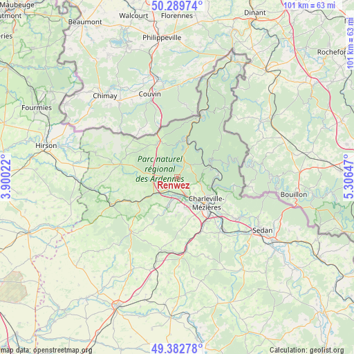
Renwez GPS coordinates[2]
49° 50' 18.204" North, 4° 36' 12.024" East
| Map corner | latitude | longitude |
|---|---|---|
| Upper-left | 50.28974°, | 3.90022° |
| Center: | 49.83839°, | 4.60334° |
| Lower-right: | 49.38278°, | 5.30647° |
| Map W x H: | 100.8×100.8 km | = 62.6×62.6mi |
| max Lat: | 51.07786° ⇑7.5% North |
| Renwez: | 49.83839° |
| min Lat: | ⇓92.5% South 41.3874° |
| min Long | Renwez | max Long |
| -5.08615° | 4.60334° | 9.52242° |
| W 72.8%⇐ | ⇒27.2% E |
Elevation
Elevation of Renwez is 278 m = 912 ft, and this is 84.3 m = 277 ft above average elevation for this country.
| Max E: |
2333 m = 7654 ft | 21.4% |
| Renwez | 278 m 912 ft | |
| Avg. | 193.7 m = 635 ft | |
Min E: |
-1 m = -3 ft | 78.6% |
See also: France elevation on elevation.city.
Geographical zone
Renwez is located in North temperate zone (between Tropic of Cancer and the Arctic Circle). Distance of this North polar circle is 1859.7 km =1155.6 mi to North.| Distance of | km | miles | from Renwez |
|---|---|---|---|
| North Pole | 4465.6 | 2774.8 | to North |
| Arctic Circle | 1859.7 | 1155.6 | to North |
| Tropic Cancer | 2935.6 | 1824.1 | to South |
| Equator | 5541.5 | 3443.3 | to South |


Nearby cities:
15 places around Renwez: (largest is in red/bold)
• Bourg-Fidèle
7.5 km =4.7 mi,  322°
322°
• Deville
8.6 km =5.3 mi,  58°
58°
• Joigny-sur-Meuse
11.3 km =7 mi,  90°
90°
• Laifour
10.5 km =6.5 mi,  37°
37°
• Les Mazures
5.7 km =3.5 mi,  16°
16°
• Monthermé
10.4 km =6.5 mi, 60°
• Nouzonville
10.7 km =6.6 mi,  104°
104°
• Prix-lès-Mézières
11.2 km =7 mi,  145°
145°
• Revin
11.6 km =7.2 mi,  11°
11°
• Rimogne
4.6 km =2.9 mi,  273°
273°
• Rocroi
11.4 km =7.1 mi,  329°
329°
• Rouvroy-sur-Audry
9.7 km =6 mi,  234°
234°
• Sormonne
4.1 km =2.5 mi,  221°
221°
• Tournes
5.3 km =3.3 mi, 151°
• Warcq
9 km =5.6 mi,  141°
141°
Sources, notices
• [Note1] Compared only with cities in France existing in our database
• [Src1] Map data: © OpenStreetMap contributors (CC-BY-SA)
• [Src2] Other city data from geonames.org with taken over terms of usage.
• [Src3] Geographical zone / Annual Mean Temperature by Robert A. Rohde @ Wikipedia
