Soissons geodata
Soissons (Hauts-de-France) is a seat of a third-order administrative division; located in France in Europe/Paris (GMT+2) time zone. With population of 31,100 people, there are 258 cities with bigger population in this country. Compared to other cities in France, 87.6% of cities are located further ↓South; 62.3% of cities are located further ←West and 81.8% of cities have higher elevation than Soissons. Note1
Administrative division(s):
- Level 1: Hauts-de-France
- Level 2: Département de l'Aisne
- Level 3: Arrondissement de Soissons
- Level 4: Soissons


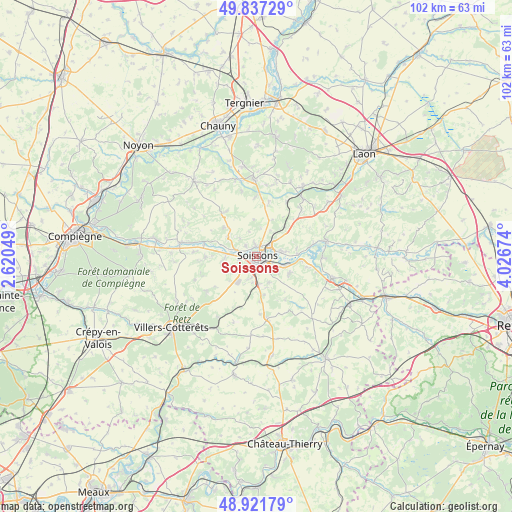
Soissons GPS coordinates[2]
49° 22' 54.012" North, 3° 19' 24.996" East
| Map corner | latitude | longitude |
|---|---|---|
| Upper-left | 49.83729°, | 2.62049° |
| Center: | 49.38167°, | 3.32361° |
| Lower-right: | 48.92179°, | 4.02674° |
| Map W x H: | 101.8×101.8 km | = 63.3×63.3mi |
| max Lat: | 51.07786° ⇑12.4% North |
| Soissons: | 49.38167° |
| min Lat: | ⇓87.6% South 41.3874° |
| min Long | Soissons | max Long |
| -5.08615° | 3.32361° | 9.52242° |
| W 62.3%⇐ | ⇒37.7% E |
Elevation
Elevation of Soissons is 50 m = 164 ft, and this is 143.7 m = 471 ft below average elevation for this country.
| Max E: |
2333 m = 7654 ft | 81.8% |
| Avg. | 193.7 m = 635 ft | |
| Soissons | 50 m = 164 ft | |
Min E: |
-1 m = -3 ft | 18.2% |
See also: France elevation on elevation.city.
Geographical zone
Soissons is located in North temperate zone (between Tropic of Cancer and the Arctic Circle). Distance of this North polar circle is 1910.4 km =1187.1 mi to North.| Distance of | km | miles | from Soissons |
|---|---|---|---|
| North Pole | 4516.3 | 2806.3 | to North |
| Arctic Circle | 1910.4 | 1187.1 | to North |
| Tropic Cancer | 2884.8 | 1792.5 | to South |
| Equator | 5490.7 | 3411.8 | to South |


Nearby cities:
15 places around Soissons: (largest is in red/bold)
• Acy
7.6 km =4.7 mi,  122°
122°
• Belleu
2.6 km =1.6 mi,  160°
160°
• Billy-sur-Aisne
5.2 km =3.2 mi, 122°
• Bucy-le-Long
5.3 km =3.3 mi,  79°
79°
• Courmelles
4.1 km =2.5 mi,  191°
191°
• Crouy
3.4 km =2.1 mi,  47°
47°
• Cuffies
2.4 km =1.5 mi,  355°
355°
• Mercin-et-Vaux
3.4 km =2.1 mi,  261°
261°
• Pasly
3 km =1.9 mi,  318°
318°
• Pernant
6.1 km =3.8 mi,  269°
269°
• Pommiers
3.9 km =2.4 mi,  289°
289°
• Septmonts
5.8 km =3.6 mi,  154°
154°
• Vauxbuin
3.3 km =2.1 mi,  219°
219°
• Venizel
5.3 km =3.3 mi,  109°
109°
• Villeneuve-Saint-Germain
2.6 km =1.6 mi,  94°
94°
Sources, notices
• [Note1] Compared only with cities in France existing in our database
• [Src1] Map data: © OpenStreetMap contributors (CC-BY-SA)
• [Src2] Other city data from geonames.org with taken over terms of usage.
• [Src3] Geographical zone / Annual Mean Temperature by Robert A. Rohde @ Wikipedia
