Acy geodata
Acy (Hauts-de-France) is a populated place; located in France in Europe/Paris (GMT+2) time zone. With population of 964 people, there are 9100 cities with bigger population in this country. Compared to other cities in France, 86.9% of cities are located further ↓South; 63.3% of cities are located further ←West and 53.9% of cities have lower elevation than Acy. Note1
Administrative division(s):
- Level 1: Hauts-de-France
- Level 2: Département de l'Aisne
- Level 3: Arrondissement de Soissons
- Level 4: Acy


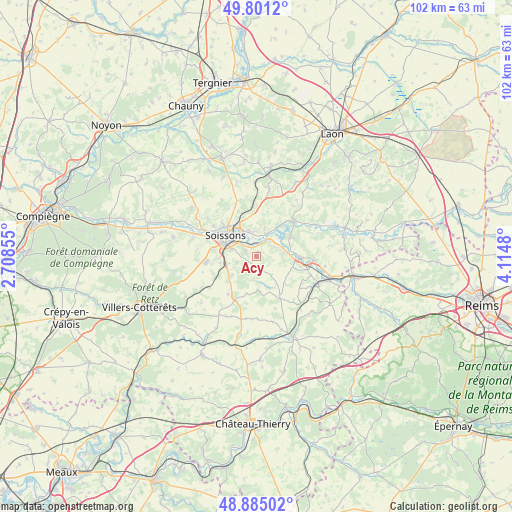
Acy GPS coordinates[2]
49° 20' 42.864" North, 3° 24' 42.012" East
| Map corner | latitude | longitude |
|---|---|---|
| Upper-left | 49.8012°, | 2.70855° |
| Center: | 49.34524°, | 3.41167° |
| Lower-right: | 48.88502°, | 4.1148° |
| Map W x H: | 101.9×101.9 km | = 63.3×63.3mi |
| max Lat: | 51.07786° ⇑13.1% North |
| Acy: | 49.34524° |
| min Lat: | ⇓86.9% South 41.3874° |
| min Long | Acy | max Long |
| -5.08615° | 3.41167° | 9.52242° |
| W 63.3%⇐ | ⇒36.7% E |
Elevation
Elevation of Acy is 146 m = 479 ft, and this is 47.7 m = 156 ft below average elevation for this country.
| Max E: |
2333 m = 7654 ft | 46.1% |
| Avg. | 193.7 m = 635 ft | |
| Acy | 146 m = 479 ft | |
Min E: |
-1 m = -3 ft | 53.9% |
See also: France elevation on elevation.city.
Geographical zone
Acy is located in North temperate zone (between Tropic of Cancer and the Arctic Circle). Distance of this North polar circle is 1914.5 km =1189.6 mi to North.| Distance of | km | miles | from Acy |
|---|---|---|---|
| North Pole | 4520.4 | 2808.8 | to North |
| Arctic Circle | 1914.5 | 1189.6 | to North |
| Tropic Cancer | 2880.8 | 1790 | to South |
| Equator | 5486.7 | 3409.3 | to South |


Nearby cities:
15 places around Acy: (largest is in red/bold)
• Belleu
5.7 km =3.5 mi,  285°
285°
• Billy-sur-Aisne
2.4 km =1.5 mi,  301°
301°
• Braine
8.8 km =5.5 mi,  91°
91°
• Bucy-le-Long
5.2 km =3.2 mi,  347°
347°
• Chassemy
7.9 km =4.9 mi,  60°
60°
• Chivres-Val
5.9 km =3.7 mi,  17°
17°
• Ciry-Salsogne
4.2 km =2.6 mi, 61°
• Courmelles
7.2 km =4.5 mi,  270°
270°
• Crouy
7.5 km =4.7 mi,  328°
328°
• Missy-sur-Aisne
4.9 km =3 mi, 20°
• Septmonts
4.1 km =2.5 mi,  253°
253°
• Soissons
7.6 km =4.7 mi, 302°
• Vauxbuin
8.6 km =5.3 mi,  279°
279°
• Venizel
2.7 km =1.7 mi, 329°
• Villeneuve-Saint-Germain
5.4 km =3.4 mi,  315°
315°
Sources, notices
• [Note1] Compared only with cities in France existing in our database
• [Src1] Map data: © OpenStreetMap contributors (CC-BY-SA)
• [Src2] Other city data from geonames.org with taken over terms of usage.
• [Src3] Geographical zone / Annual Mean Temperature by Robert A. Rohde @ Wikipedia
