Savas geodata
Savas (Auvergne-Rhône-Alpes) is a populated place; located in France in Europe/Paris (GMT+2) time zone. With population of 736 people, there are 11334 cities with bigger population in this country. Compared to other cities in France, 76.4% of cities are located further ↑North; 73.6% of cities are located further ←West and 94.4% of cities have lower elevation than Savas. Note1
Administrative division(s):
- Level 1: Auvergne-Rhône-Alpes
- Level 2: Département de l'Ardèche
- Level 3: Arrondissement de Tournon-sur-Rhône
- Level 4: Savas


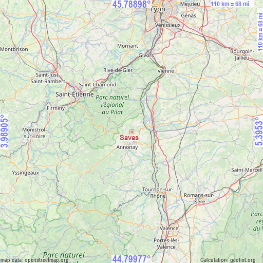
Savas GPS coordinates[2]
45° 17' 47.508" North, 4° 41' 31.848" East
| Map corner | latitude | longitude |
|---|---|---|
| Upper-left | 45.78898°, | 3.98905° |
| Center: | 45.29653°, | 4.69218° |
| Lower-right: | 44.79977°, | 5.3953° |
| Map W x H: | 110×110 km | = 68.4×68.4mi |
| max Lat: | 51.07786° ⇑76.4% North |
| Savas: | 45.29653° |
| min Lat: | ⇓23.6% South 41.3874° |
| min Long | Savas | max Long |
| -5.08615° | 4.69218° | 9.52242° |
| W 73.6%⇐ | ⇒26.4% E |
Elevation
Elevation of Savas is 557 m = 1827 ft, and this is 363.3 m = 1192 ft above average elevation for this country.
| Max E: |
2333 m = 7654 ft | 5.6% |
| Savas | 557 m 1827 ft | |
| Avg. | 193.7 m = 635 ft | |
Min E: |
-1 m = -3 ft | 94.4% |
See also: France elevation on elevation.city.
Geographical zone
Savas is located in North temperate zone (between Tropic of Cancer and the Arctic Circle). Distance of this North polar circle is 2364.7 km =1469.4 mi to North.| Distance of | km | miles | from Savas |
|---|---|---|---|
| North Pole | 4970.6 | 3088.6 | to North |
| Arctic Circle | 2364.7 | 1469.4 | to North |
| Tropic Cancer | 2430.6 | 1510.3 | to South |
| Equator | 5036.5 | 3129.5 | to South |


Nearby cities:
15 places around Savas: (largest is in red/bold)
• Annonay
6.5 km =4 mi,  194°
194°
• Boulieu-lès-Annonay
3.5 km =2.2 mi,  214°
214°
• Charnas
6 km =3.7 mi,  42°
42°
• Davézieux
4.7 km =2.9 mi,  165°
165°
• Félines
3.6 km =2.2 mi,  51°
51°
• Limony
8 km =5 mi, 39°
• Maclas
7.4 km =4.6 mi,  353°
353°
• Peaugres
3 km =1.9 mi,  111°
111°
• Sablons
7 km =4.3 mi,  67°
67°
• Saint-Appolinard
5.8 km =3.6 mi,  331°
331°
• Saint-Clair
2.2 km =1.4 mi,  203°
203°
• Saint-Cyr
5.8 km =3.6 mi,  148°
148°
• Saint-Julien-Molin-Molette
6.5 km =4 mi,  295°
295°
• Saint-Marcel-lès-Annonay
5.3 km =3.3 mi,  257°
257°
• Serrières
6 km =3.7 mi, 66°
Sources, notices
• [Note1] Compared only with cities in France existing in our database
• [Src1] Map data: © OpenStreetMap contributors (CC-BY-SA)
• [Src2] Other city data from geonames.org with taken over terms of usage.
• [Src3] Geographical zone / Annual Mean Temperature by Robert A. Rohde @ Wikipedia
