Saint-Yrieix-sur-Charente geodata
Saint-Yrieix-sur-Charente (Nouvelle-Aquitaine) is a populated place; located in France in Europe/Paris (GMT+2) time zone. With population of 6,832 people, there are 1446 cities with bigger population in this country. Compared to other cities in France, 71.2% of cities are located further ↑North; 77% of cities are located further →East and 67% of cities have higher elevation than Saint-Yrieix-sur-Charente. Note1
Administrative division(s):
- Level 1: Nouvelle-Aquitaine
- Level 2: Charente
- Level 3: Arrondissement d’Angoulême
- Level 4: Saint-Yrieix-sur-Charente
Current local time in Saint-Yrieix-sur-Charente:
05:26 PM, SaturdayDifference from your time zone: hours


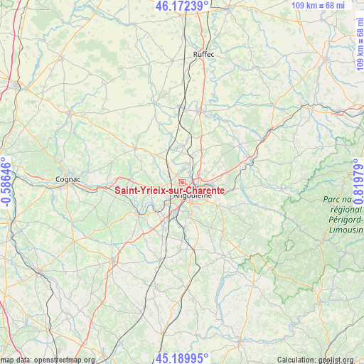
Saint-Yrieix-sur-Charente GPS coordinates[2]
45° 40' 59.988" North, 0° 7' 0.012" East
| Map corner | latitude | longitude |
|---|---|---|
| Upper-left | 46.17239°, | -0.58646° |
| Center: | 45.68333°, | 0.11667° |
| Lower-right: | 45.18995°, | 0.81979° |
| Map W x H: | 109.2×109.2 km | = 67.9×67.9mi |
| max Lat: | 51.07786° ⇑71.2% North |
| Saint-Yrieix-sur-Charente: | 45.68333° |
| min Lat: | ⇓28.8% South 41.3874° |
| min Long | Saint-Yrieix-su | max Long |
| -5.08615° | 0.11667° | 9.52242° |
| W 23%⇐ | ⇒77% E |
Elevation
Elevation of Saint-Yrieix-sur-Charente is 85 m = 279 ft, and this is 108.7 m = 357 ft below average elevation for this country.
| Max E: |
2333 m = 7654 ft | 67% |
| Avg. | 193.7 m = 635 ft | |
| Saint-Yrieix-sur-Charente | 85 m = 279 ft | |
Min E: |
-1 m = -3 ft | 33% |
See also: France elevation on elevation.city.
Geographical zone
Saint-Yrieix-sur-Charente is located in North temperate zone (between Tropic of Cancer and the Arctic Circle). Distance of this North polar circle is 2321.7 km =1442.6 mi to North.| Distance of | km | miles | from Saint-Yrieix-sur-Charente |
|---|---|---|---|
| North Pole | 4927.6 | 3061.9 | to North |
| Arctic Circle | 2321.7 | 1442.6 | to North |
| Tropic Cancer | 2473.6 | 1537 | to South |
| Equator | 5079.5 | 3156.3 | to South |


Nearby cities:
15 places around Saint-Yrieix-sur-Charente: (largest is in red/bold)
• Angoulême
4.5 km =2.8 mi,  145°
145°
• Asnières-sur-Nouère
6.4 km =4 mi,  305°
305°
• Balzac
1.9 km =1.2 mi,  0°
0°
• Champniers
7.6 km =4.7 mi,  63°
63°
• Fléac
2.3 km =1.4 mi,  214°
214°
• Gond-Pontouvre
3.9 km =2.4 mi,  90°
90°
• La Couronne
8.1 km =5 mi,  189°
189°
• Linars
4.5 km =2.8 mi, 214°
• Marsac
7.2 km =4.5 mi,  334°
334°
• Nersac
7.6 km =4.7 mi,  222°
222°
• Saint-Michel
3.9 km =2.4 mi,  199°
199°
• Saint-Saturnin
5.5 km =3.4 mi,  250°
250°
• Soyaux
7.5 km =4.7 mi,  119°
119°
• Trois-Palis
7.6 km =4.7 mi, 222°
• Vindelle
3.7 km =2.3 mi, 0°
In other languages:
- In Spanish: San Yrieix sobre Charenta
- In Russian: Сент-Ирьекс-сюр-Шарант
- In Chinese: 沙朗特河畔圣伊里耶伊
Sources, notices
• [Note1] Compared only with cities in France existing in our database
• [Src1] Map data: © OpenStreetMap contributors (CC-BY-SA)
• [Src2] Other city data from geonames.org with taken over terms of usage.
• [Src3] Geographical zone / Annual Mean Temperature by Robert A. Rohde @ Wikipedia
