Balzac geodata
Balzac (Nouvelle-Aquitaine) is a populated place; located in France in Europe/Paris (GMT+2) time zone. With population of 1,284 people, there are 7106 cities with bigger population in this country. Compared to other cities in France, 70.9% of cities are located further ↑North; 77% of cities are located further →East and 89.1% of cities have higher elevation than Balzac. Note1
Administrative division(s):
- Level 1: Nouvelle-Aquitaine
- Level 2: Charente
- Level 3: Arrondissement d’Angoulême
- Level 4: Balzac


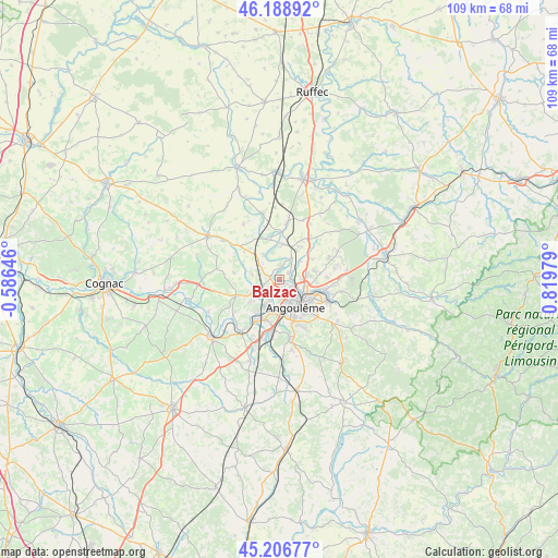
Balzac GPS coordinates[2]
45° 42' 0" North, 0° 7' 0.012" East
| Map corner | latitude | longitude |
|---|---|---|
| Upper-left | 46.18892°, | -0.58646° |
| Center: | 45.7°, | 0.11667° |
| Lower-right: | 45.20677°, | 0.81979° |
| Map W x H: | 109.2×109.2 km | = 67.9×67.9mi |
| max Lat: | 51.07786° ⇑70.9% North |
| Balzac: | 45.7° |
| min Lat: | ⇓29.1% South 41.3874° |
| min Long | Balzac | max Long |
| -5.08615° | 0.11667° | 9.52242° |
| W 23%⇐ | ⇒77% E |
Elevation
Elevation of Balzac is 32 m = 105 ft, and this is 161.7 m = 531 ft below average elevation for this country.
| Max E: |
2333 m = 7654 ft | 89.1% |
| Avg. | 193.7 m = 635 ft | |
| Balzac | 32 m = 105 ft | |
Min E: |
-1 m = -3 ft | 10.9% |
See also: France elevation on elevation.city.
Geographical zone
Balzac is located in North temperate zone (between Tropic of Cancer and the Arctic Circle). Distance of this North polar circle is 2319.8 km =1441.5 mi to North.| Distance of | km | miles | from Balzac |
|---|---|---|---|
| North Pole | 4925.7 | 3060.7 | to North |
| Arctic Circle | 2319.8 | 1441.5 | to North |
| Tropic Cancer | 2475.4 | 1538.1 | to South |
| Equator | 5081.4 | 3157.4 | to South |


Nearby cities:
15 places around Balzac: (largest is in red/bold)
• Angoulême
6.1 km =3.8 mi,  155°
155°
• Asnières-sur-Nouère
5.5 km =3.4 mi,  289°
289°
• Champniers
7 km =4.3 mi,  76°
76°
• Fléac
3.9 km =2.4 mi,  199°
199°
• Gond-Pontouvre
4.3 km =2.7 mi,  115°
115°
• Linars
6.1 km =3.8 mi, 204°
• Marsac
5.6 km =3.5 mi,  326°
326°
• Saint-Genis-d’Hiersac
8.8 km =5.5 mi,  309°
309°
• Saint-Michel
5.7 km =3.5 mi,  193°
193°
• Saint-Saturnin
6.4 km =4 mi,  234°
234°
• Saint-Yrieix-sur-Charente
1.9 km =1.2 mi,  180°
180°
• Soyaux
8.5 km =5.3 mi,  130°
130°
• Trois-Palis
9 km =5.6 mi,  214°
214°
• Vars
7 km =4.3 mi,  5°
5°
• Vindelle
1.9 km =1.2 mi,  0°
0°
Sources, notices
• [Note1] Compared only with cities in France existing in our database
• [Src1] Map data: © OpenStreetMap contributors (CC-BY-SA)
• [Src2] Other city data from geonames.org with taken over terms of usage.
• [Src3] Geographical zone / Annual Mean Temperature by Robert A. Rohde @ Wikipedia
