Saint-Vallier-de-Thiey geodata
Saint-Vallier-de-Thiey (Provence-Alpes-Côte d'Azur) is a populated place; located in France in Europe/Paris (GMT+2) time zone. With population of 2,358 people, there are 4100 cities with bigger population in this country. Compared to other cities in France, 90.5% of cities are located further ↑North; 93.9% of cities are located further ←West and 96.9% of cities have lower elevation than Saint-Vallier-de-Thiey. Note1
Administrative division(s):
- Level 1: Provence-Alpes-Côte d'Azur
- Level 2: Alpes-Maritimes
- Level 3: Arrondissement de Grasse
- Level 4: Saint-Vallier-de-Thiey
Current local time in Saint-Vallier-de-Thiey:
03:05 AM, WednesdayDifference from your time zone: hours


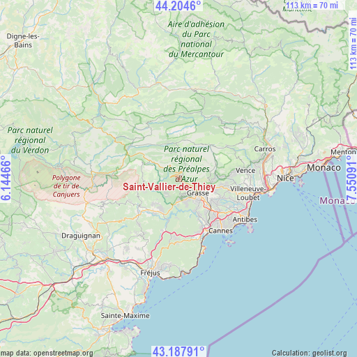
Saint-Vallier-de-Thiey GPS coordinates[2]
43° 41' 54.276" North, 6° 50' 52.044" East
| Map corner | latitude | longitude |
|---|---|---|
| Upper-left | 44.2046°, | 6.14466° |
| Center: | 43.69841°, | 6.84779° |
| Lower-right: | 43.18791°, | 7.55091° |
| Map W x H: | 113×113 km | = 70.2×70.2mi |
| max Lat: | 51.07786° ⇑90.5% North |
| Saint-Vallier-de-Thiey: | 43.69841° |
| min Lat: | ⇓9.5% South 41.3874° |
| min Long | Saint-Vallier-d | max Long |
| -5.08615° | 6.84779° | 9.52242° |
| W 93.9%⇐ | ⇒6.1% E |
Elevation
Elevation of Saint-Vallier-de-Thiey is 720 m = 2362 ft, and this is 526.3 m = 1727 ft above average elevation for this country.
| Max E: |
2333 m = 7654 ft | 3.1% |
| Saint-Vallier-de-Thiey | 720 m 2362 ft | |
| Avg. | 193.7 m = 635 ft | |
Min E: |
-1 m = -3 ft | 96.9% |
See also: France elevation on elevation.city.
Geographical zone
Saint-Vallier-de-Thiey is located in North temperate zone (between Tropic of Cancer and the Arctic Circle). Distance of this Northern Tropic circle is 2252.9 km =1399.9 mi to South.| Distance of | km | miles | from Saint-Vallier-de-Thiey |
|---|---|---|---|
| North Pole | 5148.3 | 3199 | to North |
| Arctic Circle | 2542.4 | 1579.8 | to North |
| Tropic Cancer | 2252.9 | 1399.9 | to South |
| Equator | 4858.8 | 3019.1 | to South |


Nearby cities:
15 places around Saint-Vallier-de-Thiey: (largest is in red/bold)
• Auribeau-sur-Siagne
12 km =7.5 mi,  155°
155°
• Cabris
5.1 km =3.2 mi, 156°
• Callian
11.4 km =7.1 mi,  222°
222°
• Châteauneuf-Grasse
11.5 km =7.1 mi,  107°
107°
• Grasse
7.7 km =4.8 mi,  125°
125°
• Le Bar-sur-Loup
10.9 km =6.8 mi,  89°
89°
• Le Tignet
6.5 km =4 mi,  181°
181°
• Mons
10.8 km =6.7 mi,  265°
265°
• Montauroux
11.1 km =6.9 mi, 216°
• Mouans-Sartoux
13.1 km =8.1 mi, 130°
• Opio
11.3 km =7 mi, 107°
• Peymeinade
6.6 km =4.1 mi, 160°
• Saint-Cézaire-sur-Siagne
7 km =4.3 mi, 219°
• Spéracèdes
5.6 km =3.5 mi,  170°
170°
• Tanneron
12.2 km =7.6 mi, 169°
Sources, notices
• [Note1] Compared only with cities in France existing in our database
• [Src1] Map data: © OpenStreetMap contributors (CC-BY-SA)
• [Src2] Other city data from geonames.org with taken over terms of usage.
• [Src3] Geographical zone / Annual Mean Temperature by Robert A. Rohde @ Wikipedia
