Tanneron geodata
Tanneron (Provence-Alpes-Côte d'Azur) is a populated place; located in France in Europe/Paris (GMT+2) time zone. With population of 1,410 people, there are 6565 cities with bigger population in this country. Compared to other cities in France, 92% of cities are located further ↑North; 94.1% of cities are located further ←West and 86.9% of cities have lower elevation than Tanneron. Note1
Administrative division(s):
- Level 1: Provence-Alpes-Côte d'Azur
- Level 2: Var
- Level 3: Arrondissement de Draguignan
- Level 4: Tanneron


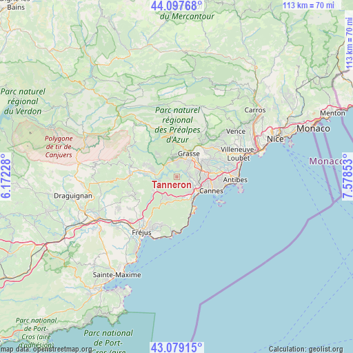
Tanneron GPS coordinates[2]
43° 35' 26.052" North, 6° 52' 31.476" East
| Map corner | latitude | longitude |
|---|---|---|
| Upper-left | 44.09768°, | 6.17228° |
| Center: | 43.59057°, | 6.87541° |
| Lower-right: | 43.07915°, | 7.57853° |
| Map W x H: | 113.2×113.2 km | = 70.3×70.3mi |
| max Lat: | 51.07786° ⇑92% North |
| Tanneron: | 43.59057° |
| min Lat: | ⇓8% South 41.3874° |
| min Long | Tanneron | max Long |
| -5.08615° | 6.87541° | 9.52242° |
| W 94.1%⇐ | ⇒5.9% E |
Elevation
Elevation of Tanneron is 371 m = 1217 ft, and this is 177.3 m = 582 ft above average elevation for this country.
| Max E: |
2333 m = 7654 ft | 13.1% |
| Tanneron | 371 m 1217 ft | |
| Avg. | 193.7 m = 635 ft | |
Min E: |
-1 m = -3 ft | 86.9% |
See also: France elevation on elevation.city.
Geographical zone
Tanneron is located in North temperate zone (between Tropic of Cancer and the Arctic Circle). Distance of this Northern Tropic circle is 2240.9 km =1392.4 mi to South.| Distance of | km | miles | from Tanneron |
|---|---|---|---|
| North Pole | 5160.2 | 3206.4 | to North |
| Arctic Circle | 2554.4 | 1587.2 | to North |
| Tropic Cancer | 2240.9 | 1392.4 | to South |
| Equator | 4846.8 | 3011.7 | to South |


Nearby cities:
15 places around Tanneron: (largest is in red/bold)
• Auribeau-sur-Siagne
3 km =1.9 mi,  68°
68°
• Cabris
7.3 km =4.5 mi,  358°
358°
• Callian
10.5 km =6.5 mi,  289°
289°
• Grasse
8.5 km =5.3 mi,  28°
28°
• La Roquette-sur-Siagne
6.6 km =4.1 mi,  82°
82°
• Le Tignet
6 km =3.7 mi,  336°
336°
• Mandelieu-la-Napoule
7.1 km =4.4 mi,  134°
134°
• Montauroux
9.4 km =5.8 mi, 289°
• Mouans-Sartoux
8.4 km =5.2 mi, 66°
• Mougins
9.7 km =6 mi, 83°
• Peymeinade
5.8 km =3.6 mi,  0°
0°
• Pégomas
4.6 km =2.9 mi, 81°
• Saint-Cézaire-sur-Siagne
9.4 km =5.8 mi,  314°
314°
• Spéracèdes
6.6 km =4.1 mi,  348°
348°
• Théoule-sur-Mer
10.6 km =6.6 mi,  150°
150°
Sources, notices
• [Note1] Compared only with cities in France existing in our database
• [Src1] Map data: © OpenStreetMap contributors (CC-BY-SA)
• [Src2] Other city data from geonames.org with taken over terms of usage.
• [Src3] Geographical zone / Annual Mean Temperature by Robert A. Rohde @ Wikipedia
