Saint-Selve geodata
Saint-Selve (Nouvelle-Aquitaine) is a populated place; located in France in Europe/Paris (GMT+2) time zone. With population of 1,758 people, there are 5386 cities with bigger population in this country. Compared to other cities in France, 82.3% of cities are located further ↑North; 83.1% of cities are located further →East and 96% of cities have higher elevation than Saint-Selve. Note1
Administrative division(s):
- Level 1: Nouvelle-Aquitaine
- Level 2: Gironde
- Level 3: Arrondissement de Bordeaux
- Level 4: Saint-Selve


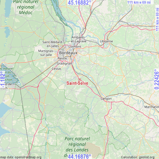
Saint-Selve GPS coordinates[2]
44° 40' 15.42" North, 0° 28' 43.932" West
| Map corner | latitude | longitude |
|---|---|---|
| Upper-left | 45.16882°, | -1.182° |
| Center: | 44.67095°, | -0.47887° |
| Lower-right: | 44.16876°, | 0.22426° |
| Map W x H: | 111.2×111.2 km | = 69.1×69.1mi |
| max Lat: | 51.07786° ⇑82.3% North |
| Saint-Selve: | 44.67095° |
| min Lat: | ⇓17.7% South 41.3874° |
| min Long | Saint-Selve | max Long |
| -5.08615° | -0.47887° | 9.52242° |
| W 16.9%⇐ | ⇒83.1% E |
Elevation
Elevation of Saint-Selve is 14 m = 46 ft, and this is 179.7 m = 590 ft below average elevation for this country.
| Max E: |
2333 m = 7654 ft | 96% |
| Avg. | 193.7 m = 635 ft | |
| Saint-Selve | 14 m = 46 ft | |
Min E: |
-1 m = -3 ft | 4% |
See also: France elevation on elevation.city.
Geographical zone
Saint-Selve is located in North temperate zone (between Tropic of Cancer and the Arctic Circle). Distance of this Northern Tropic circle is 2361 km =1467.1 mi to South.| Distance of | km | miles | from Saint-Selve |
|---|---|---|---|
| North Pole | 5040.1 | 3131.8 | to North |
| Arctic Circle | 2434.2 | 1512.5 | to North |
| Tropic Cancer | 2361 | 1467.1 | to South |
| Equator | 4966.9 | 3086.3 | to South |


Nearby cities:
15 places around Saint-Selve: (largest is in red/bold)
• Arbanats
6.7 km =4.2 mi,  85°
85°
• Ayguemorte-les-Graves
4.3 km =2.7 mi,  358°
358°
• Baurech
6.9 km =4.3 mi,  27°
27°
• Beautiran
4.2 km =2.6 mi, 30°
• Cambes
6.9 km =4.3 mi,  10°
10°
• Castres-Gironde
3.7 km =2.3 mi,  43°
43°
• Isle-Saint-Georges
6 km =3.7 mi,  4°
4°
• Langoiran
7.9 km =4.9 mi,  58°
58°
• Le Tourne
7.3 km =4.5 mi,  52°
52°
• Martillac
6.4 km =4 mi,  313°
313°
• Portets
5.2 km =3.2 mi, 56°
• Saint-Michel-de-Rieufret
6.4 km =4 mi,  146°
146°
• Saint-Morillon
3 km =1.9 mi,  220°
220°
• Saint-Médard-d’Eyrans
5.9 km =3.7 mi,  329°
329°
• Virelade
7.8 km =4.8 mi, 94°
Sources, notices
• [Note1] Compared only with cities in France existing in our database
• [Src1] Map data: © OpenStreetMap contributors (CC-BY-SA)
• [Src2] Other city data from geonames.org with taken over terms of usage.
• [Src3] Geographical zone / Annual Mean Temperature by Robert A. Rohde @ Wikipedia
