Langoiran geodata
Langoiran (Nouvelle-Aquitaine) is a populated place; located in France in Europe/Paris (GMT+2) time zone. With population of 2,168 people, there are 4426 cities with bigger population in this country. Compared to other cities in France, 82% of cities are located further ↑North; 82% of cities are located further →East and 77% of cities have higher elevation than Langoiran. Note1
Administrative division(s):
- Level 1: Nouvelle-Aquitaine
- Level 2: Gironde
- Level 3: Arrondissement de Langon
- Level 4: Langoiran


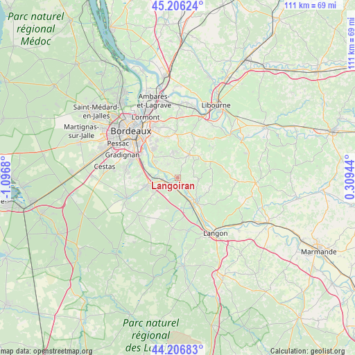
Langoiran GPS coordinates[2]
44° 42' 31.284" North, 0° 23' 37.248" West
| Map corner | latitude | longitude |
|---|---|---|
| Upper-left | 45.20624°, | -1.0968° |
| Center: | 44.70869°, | -0.39368° |
| Lower-right: | 44.20683°, | 0.30944° |
| Map W x H: | 111.1×111.1 km | = 69×69mi |
| max Lat: | 51.07786° ⇑82% North |
| Langoiran: | 44.70869° |
| min Lat: | ⇓18% South 41.3874° |
| min Long | Langoiran | max Long |
| -5.08615° | -0.39368° | 9.52242° |
| W 18%⇐ | ⇒82% E |
Elevation
Elevation of Langoiran is 62 m = 203 ft, and this is 131.7 m = 432 ft below average elevation for this country.
| Max E: |
2333 m = 7654 ft | 77% |
| Avg. | 193.7 m = 635 ft | |
| Langoiran | 62 m = 203 ft | |
Min E: |
-1 m = -3 ft | 23% |
See also: France elevation on elevation.city.
Geographical zone
Langoiran is located in North temperate zone (between Tropic of Cancer and the Arctic Circle). Distance of this Northern Tropic circle is 2365.2 km =1469.7 mi to South.| Distance of | km | miles | from Langoiran |
|---|---|---|---|
| North Pole | 5035.9 | 3129.2 | to North |
| Arctic Circle | 2430 | 1509.9 | to North |
| Tropic Cancer | 2365.2 | 1469.7 | to South |
| Equator | 4971.1 | 3088.9 | to South |


Nearby cities:
15 places around Langoiran: (largest is in red/bold)
• Arbanats
3.7 km =2.3 mi,  181°
181°
• Baurech
4 km =2.5 mi,  297°
297°
• Beautiran
4.6 km =2.9 mi,  263°
263°
• Cambes
6 km =3.7 mi, 295°
• Capian
5 km =3.1 mi,  87°
87°
• Castres-Gironde
4.5 km =2.8 mi,  249°
249°
• Haux
3.5 km =2.2 mi,  31°
31°
• Le Tourne
0.9 km =0.6 mi,  284°
284°
• Lestiac-sur-Garonne
2.2 km =1.4 mi,  136°
136°
• Paillet
3.5 km =2.2 mi, 139°
• Portets
2.8 km =1.7 mi,  241°
241°
• Rions
6 km =3.7 mi,  146°
146°
• Saint-Caprais-de-Bordeaux
5.3 km =3.3 mi,  325°
325°
• Tabanac
1.6 km =1 mi, 325°
• Virelade
4.9 km =3 mi,  167°
167°
Sources, notices
• [Note1] Compared only with cities in France existing in our database
• [Src1] Map data: © OpenStreetMap contributors (CC-BY-SA)
• [Src2] Other city data from geonames.org with taken over terms of usage.
• [Src3] Geographical zone / Annual Mean Temperature by Robert A. Rohde @ Wikipedia
