Saint-Philibert geodata
Saint-Philibert (Brittany) is a populated place; located in France in Europe/Paris (GMT+2) time zone. With population of 1,344 people, there are 6843 cities with bigger population in this country. Compared to other cities in France, 52.5% of cities are located further ↓South; 97.3% of cities are located further →East and 96% of cities have higher elevation than Saint-Philibert. Note1
Administrative division(s):
- Level 1: Brittany
- Level 2: Morbihan
- Level 3: Arrondissement de Lorient
- Level 4: Saint-Philibert


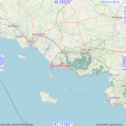
Saint-Philibert GPS coordinates[2]
47° 35' 17.556" North, 2° 59' 59.208" West
| Map corner | latitude | longitude |
|---|---|---|
| Upper-left | 48.06029°, | -3.7029° |
| Center: | 47.58821°, | -2.99978° |
| Lower-right: | 47.11183°, | -2.29665° |
| Map W x H: | 105.5×105.5 km | = 65.6×65.6mi |
| max Lat: | 51.07786° ⇑47.5% North |
| Saint-Philibert: | 47.58821° |
| min Lat: | ⇓52.5% South 41.3874° |
| min Long | Saint-Philibert | max Long |
| -5.08615° | -2.99978° | 9.52242° |
| W 2.7%⇐ | ⇒97.3% E |
Elevation
Elevation of Saint-Philibert is 14 m = 46 ft, and this is 179.7 m = 590 ft below average elevation for this country.
| Max E: |
2333 m = 7654 ft | 96% |
| Avg. | 193.7 m = 635 ft | |
| Saint-Philibert | 14 m = 46 ft | |
Min E: |
-1 m = -3 ft | 4% |
See also: France elevation on elevation.city.
Geographical zone
Saint-Philibert is located in North temperate zone (between Tropic of Cancer and the Arctic Circle). Distance of this North polar circle is 2109.9 km =1311 mi to North.| Distance of | km | miles | from Saint-Philibert |
|---|---|---|---|
| North Pole | 4715.7 | 2930.2 | to North |
| Arctic Circle | 2109.9 | 1311 | to North |
| Tropic Cancer | 2685.4 | 1668.6 | to South |
| Equator | 5291.3 | 3287.9 | to South |


Nearby cities:
15 places around Saint-Philibert: (largest is in red/bold)
• Arzon
9.4 km =5.8 mi,  118°
118°
• Auray
9.1 km =5.7 mi,  3°
3°
• Baden
6.8 km =4.2 mi,  61°
61°
• Carnac
6 km =3.7 mi,  264°
264°
• Crach
3.2 km =2 mi,  357°
357°
• La Trinité-sur-Mer
2.3 km =1.4 mi,  266°
266°
• Larmor-Baden
7.9 km =4.9 mi,  93°
93°
• Le Bono
7 km =4.3 mi,  32°
32°
• Locmariaquer
4.6 km =2.9 mi, 117°
• Ploemel
8.8 km =5.5 mi,  323°
323°
• Plougoumelen
9.3 km =5.8 mi,  41°
41°
• Plouharnel
8.5 km =5.3 mi,  277°
277°
• Pluneret
10.2 km =6.3 mi,  17°
17°
• Saint-Pierre-Quiberon
12.4 km =7.7 mi,  232°
232°
• Île-aux-Moines
11.7 km =7.3 mi, 85°
Sources, notices
• [Note1] Compared only with cities in France existing in our database
• [Src1] Map data: © OpenStreetMap contributors (CC-BY-SA)
• [Src2] Other city data from geonames.org with taken over terms of usage.
• [Src3] Geographical zone / Annual Mean Temperature by Robert A. Rohde @ Wikipedia
