Île-aux-Moines geodata
Île-aux-Moines (Brittany) is a populated place; located in France in Europe/Paris (GMT+2) time zone. With population of 601 people, there are 13304 cities with bigger population in this country. Compared to other cities in France, 52.6% of cities are located further ↓South; 97% of cities are located further →East and 94.4% of cities have higher elevation than Île-aux-Moines. Note1
Administrative division(s):
- Level 1: Brittany
- Level 2: Morbihan
- Level 3: Arrondissement de Vannes
- Level 4: Île-aux-Moines


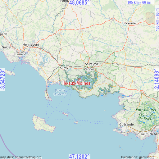
Île-aux-Moines GPS coordinates[2]
47° 35' 47.4" North, 2° 50' 38.76" West
| Map corner | latitude | longitude |
|---|---|---|
| Upper-left | 48.0685°, | -3.54723° |
| Center: | 47.5965°, | -2.8441° |
| Lower-right: | 47.1202°, | -2.14098° |
| Map W x H: | 105.4×105.4 km | = 65.5×65.5mi |
| max Lat: | 51.07786° ⇑47.4% North |
| Île-aux-Moines: | 47.5965° |
| min Lat: | ⇓52.6% South 41.3874° |
| min Long | Île-aux-Moines | max Long |
| -5.08615° | -2.8441° | 9.52242° |
| W 3%⇐ | ⇒97% E |
Elevation
Elevation of Île-aux-Moines is 19 m = 62 ft, and this is 174.7 m = 573 ft below average elevation for this country.
| Max E: |
2333 m = 7654 ft | 94.4% |
| Avg. | 193.7 m = 635 ft | |
| Île-aux-Moines | 19 m = 62 ft | |
Min E: |
-1 m = -3 ft | 5.6% |
See also: France elevation on elevation.city.
Geographical zone
Île-aux-Moines is located in North temperate zone (between Tropic of Cancer and the Arctic Circle). Distance of this North polar circle is 2108.9 km =1310.4 mi to North.| Distance of | km | miles | from Île-aux-Moines |
|---|---|---|---|
| North Pole | 4714.8 | 2929.6 | to North |
| Arctic Circle | 2108.9 | 1310.4 | to North |
| Tropic Cancer | 2686.3 | 1669.2 | to South |
| Equator | 5292.2 | 3288.4 | to South |


Nearby cities:
15 places around Île-aux-Moines: (largest is in red/bold)
• Arradon
3.8 km =2.4 mi,  26°
26°
• Arzon
6.3 km =3.9 mi,  212°
212°
• Baden
6.1 km =3.8 mi,  292°
292°
• Larmor-Baden
4 km =2.5 mi,  248°
248°
• Le Bono
9.3 km =5.8 mi,  302°
302°
• Le Hézo
10.7 km =6.6 mi,  96°
96°
• Locmariaquer
8.1 km =5 mi, 248°
• Plescop
11.6 km =7.2 mi,  14°
14°
• Ploeren
6.9 km =4.3 mi,  347°
347°
• Plougoumelen
8.1 km =5 mi,  317°
317°
• Saint-Armel
10.4 km =6.5 mi, 104°
• Saint-Gildas-de-Rhuys
10.7 km =6.6 mi,  177°
177°
• Sarzeau
9.5 km =5.9 mi,  143°
143°
• Séné
8.4 km =5.2 mi,  72°
72°
• Vannes
9.5 km =5.9 mi,  44°
44°
Sources, notices
• [Note1] Compared only with cities in France existing in our database
• [Src1] Map data: © OpenStreetMap contributors (CC-BY-SA)
• [Src2] Other city data from geonames.org with taken over terms of usage.
• [Src3] Geographical zone / Annual Mean Temperature by Robert A. Rohde @ Wikipedia
