Saint-Pé-de-Bigorre geodata
Saint-Pé-de-Bigorre (Occitanie) is a populated place; located in France in Europe/Paris (GMT+2) time zone. With population of 1,391 people, there are 6643 cities with bigger population in this country. Compared to other cities in France, 97.9% of cities are located further ↑North; 79.3% of cities are located further →East and 85.8% of cities have lower elevation than Saint-Pé-de-Bigorre. Note1
Administrative division(s):
- Level 1: Occitanie
- Level 2: Département des Hautes-Pyrénées
- Level 3: Arrondissement d’Argelès-Gazost
- Level 4: Saint-Pé-de-Bigorre


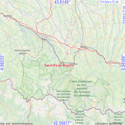
Saint-Pé-de-Bigorre GPS coordinates[2]
43° 6' 13.284" North, 0° 9' 33.948" West
| Map corner | latitude | longitude |
|---|---|---|
| Upper-left | 43.6149°, | -0.86255° |
| Center: | 43.10369°, | -0.15943° |
| Lower-right: | 42.58817°, | 0.54369° |
| Map W x H: | 114.2×114.2 km | = 71×71mi |
| max Lat: | 51.07786° ⇑97.9% North |
| Saint-Pé-de-Bigorre: | 43.10369° |
| min Lat: | ⇓2.1% South 41.3874° |
| min Long | Saint-Pé-de-Bi | max Long |
| -5.08615° | -0.15943° | 9.52242° |
| W 20.7%⇐ | ⇒79.3% E |
Elevation
Elevation of Saint-Pé-de-Bigorre is 359 m = 1178 ft, and this is 165.3 m = 542 ft above average elevation for this country.
| Max E: |
2333 m = 7654 ft | 14.2% |
| Saint-Pé-de-Bigorre | 359 m 1178 ft | |
| Avg. | 193.7 m = 635 ft | |
Min E: |
-1 m = -3 ft | 85.8% |
See also: France elevation on elevation.city.
Geographical zone
Saint-Pé-de-Bigorre is located in North temperate zone (between Tropic of Cancer and the Arctic Circle). Distance of this Northern Tropic circle is 2186.8 km =1358.8 mi to South.| Distance of | km | miles | from Saint-Pé-de-Bigorre |
|---|---|---|---|
| North Pole | 5214.4 | 3240.1 | to North |
| Arctic Circle | 2608.5 | 1620.8 | to North |
| Tropic Cancer | 2186.8 | 1358.8 | to South |
| Equator | 4792.7 | 2978 | to South |


Nearby cities:
15 places around Saint-Pé-de-Bigorre: (largest is in red/bold)
• Adé
10.8 km =6.7 mi,  72°
72°
• Arthez-d’Asson
7.7 km =4.8 mi,  252°
252°
• Asson
9 km =5.6 mi,  305°
305°
• Bordères
11.7 km =7.3 mi,  336°
336°
• Bruges-Capbis-Mifaget
11.9 km =7.4 mi,  286°
286°
• Bénéjacq
11.7 km =7.3 mi, 336°
• Coarraze
9.2 km =5.7 mi,  319°
319°
• Igon
9.2 km =5.7 mi, 319°
• Lamarque-Pontacq
9 km =5.6 mi,  23°
23°
• Lestelle-Bétharram
5.7 km =3.5 mi, 305°
• Lourdes
8.9 km =5.5 mi,  92°
92°
• Mirepeix
11.5 km =7.1 mi, 320°
• Montaut
4.7 km =2.9 mi, 315°
• Pontacq
9.5 km =5.9 mi, 21°
• Poueyferré
7.7 km =4.8 mi,  79°
79°
Sources, notices
• [Note1] Compared only with cities in France existing in our database
• [Src1] Map data: © OpenStreetMap contributors (CC-BY-SA)
• [Src2] Other city data from geonames.org with taken over terms of usage.
• [Src3] Geographical zone / Annual Mean Temperature by Robert A. Rohde @ Wikipedia
