Lestelle-Bétharram geodata
Lestelle-Bétharram (Nouvelle-Aquitaine) is a populated place; located in France in Europe/Paris (GMT+2) time zone. With population of 1,094 people, there are 8167 cities with bigger population in this country. Compared to other cities in France, 97.7% of cities are located further ↑North; 79.9% of cities are located further →East and 80.5% of cities have lower elevation than Lestelle-Bétharram. Note1
Administrative division(s):
- Level 1: Nouvelle-Aquitaine
- Level 2: Département des Pyrénées-Atlantiques
- Level 3: Arrondissement de Pau
- Level 4: Lestelle-Bétharram


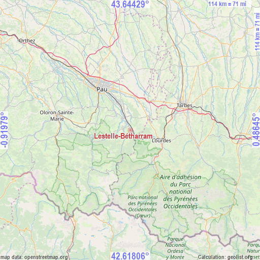
Lestelle-Bétharram GPS coordinates[2]
43° 7' 59.988" North, 0° 13' 0.012" West
| Map corner | latitude | longitude |
|---|---|---|
| Upper-left | 43.64429°, | -0.91979° |
| Center: | 43.13333°, | -0.21667° |
| Lower-right: | 42.61806°, | 0.48645° |
| Map W x H: | 114.1×114.1 km | = 70.9×70.9mi |
| max Lat: | 51.07786° ⇑97.7% North |
| Lestelle-Bétharram: | 43.13333° |
| min Lat: | ⇓2.3% South 41.3874° |
| min Long | Lestelle-Bétha | max Long |
| -5.08615° | -0.21667° | 9.52242° |
| W 20.1%⇐ | ⇒79.9% E |
Elevation
Elevation of Lestelle-Bétharram is 296 m = 971 ft, and this is 102.3 m = 336 ft above average elevation for this country.
| Max E: |
2333 m = 7654 ft | 19.5% |
| Lestelle-Bétharram | 296 m 971 ft | |
| Avg. | 193.7 m = 635 ft | |
Min E: |
-1 m = -3 ft | 80.5% |
See also: France elevation on elevation.city.
Geographical zone
Lestelle-Bétharram is located in North temperate zone (between Tropic of Cancer and the Arctic Circle). Distance of this Northern Tropic circle is 2190.1 km =1360.9 mi to South.| Distance of | km | miles | from Lestelle-Bétharram |
|---|---|---|---|
| North Pole | 5211.1 | 3238 | to North |
| Arctic Circle | 2605.2 | 1618.8 | to North |
| Tropic Cancer | 2190.1 | 1360.9 | to South |
| Equator | 4796 | 2980.1 | to South |


Nearby cities:
15 places around Lestelle-Bétharram: (largest is in red/bold)
• Arros-de-Nay
9.2 km =5.7 mi,  323°
323°
• Arthez-d’Asson
6.2 km =3.9 mi,  205°
205°
• Asson
3.3 km =2.1 mi,  304°
304°
• Baudreix
8.5 km =5.3 mi,  336°
336°
• Beuste
9.4 km =5.8 mi,  351°
351°
• Bordères
7.4 km =4.6 mi,  0°
0°
• Bruges-Capbis-Mifaget
6.8 km =4.2 mi,  270°
270°
• Bénéjacq
7.4 km =4.6 mi, 0°
• Coarraze
3.9 km =2.4 mi, 339°
• Igon
3.9 km =2.4 mi, 339°
• Lagos
9.3 km =5.8 mi, 0°
• Mirepeix
6.2 km =3.9 mi,  334°
334°
• Montaut
1.4 km =0.9 mi,  90°
90°
• Nay
6.9 km =4.3 mi, 323°
• Saint-Pé-de-Bigorre
5.7 km =3.5 mi,  125°
125°
Sources, notices
• [Note1] Compared only with cities in France existing in our database
• [Src1] Map data: © OpenStreetMap contributors (CC-BY-SA)
• [Src2] Other city data from geonames.org with taken over terms of usage.
• [Src3] Geographical zone / Annual Mean Temperature by Robert A. Rohde @ Wikipedia
