Saint-Méard-de-Gurçon geodata
Saint-Méard-de-Gurçon (Nouvelle-Aquitaine) is a populated place; located in France in Europe/Paris (GMT+2) time zone. With population of 827 people, there are 10320 cities with bigger population in this country. Compared to other cities in France, 80.5% of cities are located further ↑North; 76.4% of cities are located further →East and 74.6% of cities have higher elevation than Saint-Méard-de-Gurçon. Note1
Administrative division(s):
- Level 1: Nouvelle-Aquitaine
- Level 2: Dordogne
- Level 3: Arrondissement de Bergerac
- Level 4: Saint-Méard-de-Gurçon
Current local time in Saint-Méard-de-Gurçon:
04:51 PM, SaturdayDifference from your time zone: hours


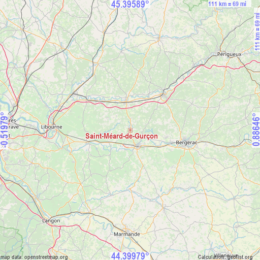
Saint-Méard-de-Gurçon GPS coordinates[2]
44° 54' 0" North, 0° 10' 59.988" East
| Map corner | latitude | longitude |
|---|---|---|
| Upper-left | 45.39589°, | -0.51979° |
| Center: | 44.9°, | 0.18333° |
| Lower-right: | 44.39979°, | 0.88646° |
| Map W x H: | 110.8×110.8 km | = 68.8×68.8mi |
| max Lat: | 51.07786° ⇑80.5% North |
| Saint-Méard-de-Gurçon: | 44.9° |
| min Lat: | ⇓19.5% South 41.3874° |
| min Long | Saint-Méard-de | max Long |
| -5.08615° | 0.18333° | 9.52242° |
| W 23.6%⇐ | ⇒76.4% E |
Elevation
Elevation of Saint-Méard-de-Gurçon is 68 m = 223 ft, and this is 125.7 m = 412 ft below average elevation for this country.
| Max E: |
2333 m = 7654 ft | 74.6% |
| Avg. | 193.7 m = 635 ft | |
| Saint-Méard-de-Gurçon | 68 m = 223 ft | |
Min E: |
-1 m = -3 ft | 25.4% |
See also: France elevation on elevation.city.
Geographical zone
Saint-Méard-de-Gurçon is located in North temperate zone (between Tropic of Cancer and the Arctic Circle). Distance of this Northern Tropic circle is 2386.5 km =1482.9 mi to South.| Distance of | km | miles | from Saint-Méard-de-Gurçon |
|---|---|---|---|
| North Pole | 5014.6 | 3115.9 | to North |
| Arctic Circle | 2408.8 | 1496.8 | to North |
| Tropic Cancer | 2386.5 | 1482.9 | to South |
| Equator | 4992.4 | 3102.1 | to South |


Nearby cities:
15 places around Saint-Méard-de-Gurçon: (largest is in red/bold)
• Flaujagues
12.9 km =8 mi,  234°
234°
• Gardonne
15.1 km =9.4 mi,  119°
119°
• Gensac
13.6 km =8.5 mi,  219°
219°
• Lamothe-Montravel
13.1 km =8.1 mi,  244°
244°
• Le Fleix
6.4 km =4 mi,  125°
125°
• Montcaret
10.7 km =6.6 mi, 238°
• Montpon-Ménestérol
11.2 km =7 mi,  353°
353°
• Ménesplet
14 km =8.7 mi,  337°
337°
• Port-Sainte-Foy-et-Ponchapt
7.5 km =4.7 mi,  169°
169°
• Saint-Antoine-de-Breuilh
7.5 km =4.7 mi,  190°
190°
• Saint-Martin-de-Gurson
8.4 km =5.2 mi,  314°
314°
• Saint-Seurin-de-Prats
10.8 km =6.7 mi, 226°
• Sainte-Foy-la-Grande
7.9 km =4.9 mi,  160°
160°
• Villefranche-de-Lonchat
11.9 km =7.4 mi,  297°
297°
• Vélines
7.6 km =4.7 mi, 223°
Sources, notices
• [Note1] Compared only with cities in France existing in our database
• [Src1] Map data: © OpenStreetMap contributors (CC-BY-SA)
• [Src2] Other city data from geonames.org with taken over terms of usage.
• [Src3] Geographical zone / Annual Mean Temperature by Robert A. Rohde @ Wikipedia
