Saint-Mayeux geodata
Saint-Mayeux (Brittany) is a populated place; located in France in Europe/Paris (GMT+2) time zone. With population of 505 people, there are 15148 cities with bigger population in this country. Compared to other cities in France, 63.8% of cities are located further ↓South; 97.3% of cities are located further →East and 78.4% of cities have lower elevation than Saint-Mayeux. Note1
Administrative division(s):
- Level 1: Brittany
- Level 2: Département des Côtes-d’Armor
- Level 3: Arrondissement de Saint-Brieuc
- Level 4: Saint-Mayeux


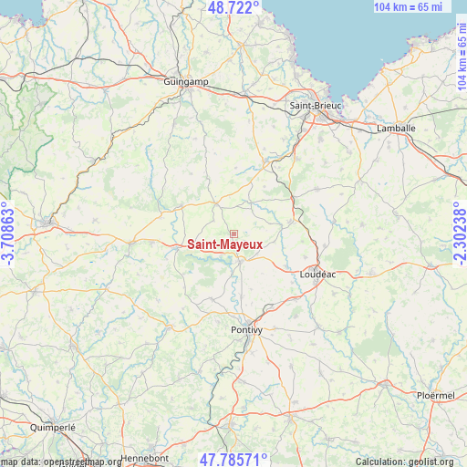
Saint-Mayeux GPS coordinates[2]
48° 15' 21.6" North, 3° 0' 19.8" West
| Map corner | latitude | longitude |
|---|---|---|
| Upper-left | 48.722°, | -3.70863° |
| Center: | 48.256°, | -3.0055° |
| Lower-right: | 47.78571°, | -2.30238° |
| Map W x H: | 104.1×104.1 km | = 64.7×64.7mi |
| max Lat: | 51.07786° ⇑36.2% North |
| Saint-Mayeux: | 48.256° |
| min Lat: | ⇓63.8% South 41.3874° |
| min Long | Saint-Mayeux | max Long |
| -5.08615° | -3.0055° | 9.52242° |
| W 2.7%⇐ | ⇒97.3% E |
Elevation
Elevation of Saint-Mayeux is 275 m = 902 ft, and this is 81.3 m = 267 ft above average elevation for this country.
| Max E: |
2333 m = 7654 ft | 21.6% |
| Saint-Mayeux | 275 m 902 ft | |
| Avg. | 193.7 m = 635 ft | |
Min E: |
-1 m = -3 ft | 78.4% |
See also: France elevation on elevation.city.
Geographical zone
Saint-Mayeux is located in North temperate zone (between Tropic of Cancer and the Arctic Circle). Distance of this North polar circle is 2035.6 km =1264.9 mi to North.| Distance of | km | miles | from Saint-Mayeux |
|---|---|---|---|
| North Pole | 4641.5 | 2884.1 | to North |
| Arctic Circle | 2035.6 | 1264.9 | to North |
| Tropic Cancer | 2759.6 | 1714.7 | to South |
| Equator | 5365.6 | 3334 | to South |


Nearby cities:
15 places around Saint-Mayeux: (largest is in red/bold)
• Allineuc
11.6 km =7.2 mi,  58°
58°
• Corlay
7.8 km =4.8 mi,  330°
330°
• Gouarec
13.3 km =8.3 mi,  256°
256°
• Kergrist
12.7 km =7.9 mi,  163°
163°
• Laniscat
8.8 km =5.5 mi, 260°
• Le Haut-Corlay
8.1 km =5 mi, 332°
• Le Quillio
9.2 km =5.7 mi,  99°
99°
• Merléac
8.3 km =5.2 mi,  73°
73°
• Mûr-de-Bretagne
6.4 km =4 mi,  165°
165°
• Neulliac
14.3 km =8.9 mi, 173°
• Plussulien
5.6 km =3.5 mi,  301°
301°
• Saint-Aignan
8.3 km =5.2 mi,  184°
184°
• Saint-Caradec
13.8 km =8.6 mi,  119°
119°
• Saint-Nicolas-du-Pélem
13.3 km =8.3 mi, 297°
• Uzel
12.6 km =7.8 mi,  77°
77°
Sources, notices
• [Note1] Compared only with cities in France existing in our database
• [Src1] Map data: © OpenStreetMap contributors (CC-BY-SA)
• [Src2] Other city data from geonames.org with taken over terms of usage.
• [Src3] Geographical zone / Annual Mean Temperature by Robert A. Rohde @ Wikipedia
