Saint-Martin-en-Bresse geodata
Saint-Martin-en-Bresse (Bourgogne-Franche-Comté) is a populated place; located in France in Europe/Paris (GMT+2) time zone. With population of 1,825 people, there are 5200 cities with bigger population in this country. Compared to other cities in France, 57% of cities are located further ↑North; 78.3% of cities are located further ←West and 64.2% of cities have lower elevation than Saint-Martin-en-Bresse. Note1
Administrative division(s):
- Level 1: Bourgogne-Franche-Comté
- Level 2: Département de Saône-et-Loire
- Level 3: Arrondissement de Chalon-sur-Saône
- Level 4: Saint-Martin-en-Bresse


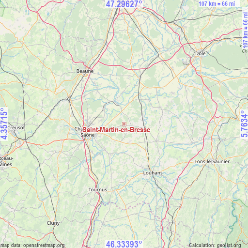
Saint-Martin-en-Bresse GPS coordinates[2]
46° 49' 2.1" North, 5° 3' 36.972" East
| Map corner | latitude | longitude |
|---|---|---|
| Upper-left | 47.29627°, | 4.35715° |
| Center: | 46.81725°, | 5.06027° |
| Lower-right: | 46.33393°, | 5.7634° |
| Map W x H: | 107×107 km | = 66.5×66.5mi |
| max Lat: | 51.07786° ⇑57% North |
| Saint-Martin-en-Bresse: | 46.81725° |
| min Lat: | ⇓43% South 41.3874° |
| min Long | Saint-Martin-en | max Long |
| -5.08615° | 5.06027° | 9.52242° |
| W 78.3%⇐ | ⇒21.7% E |
Elevation
Elevation of Saint-Martin-en-Bresse is 190 m = 623 ft, and this is 3.7 m = 12 ft below average elevation for this country.
| Max E: |
2333 m = 7654 ft | 35.8% |
| Avg. | 193.7 m = 635 ft | |
| Saint-Martin-en-Bresse | 190 m = 623 ft | |
Min E: |
-1 m = -3 ft | 64.2% |
See also: France elevation on elevation.city.
Geographical zone
Saint-Martin-en-Bresse is located in North temperate zone (between Tropic of Cancer and the Arctic Circle). Distance of this North polar circle is 2195.6 km =1364.3 mi to North.| Distance of | km | miles | from Saint-Martin-en-Bresse |
|---|---|---|---|
| North Pole | 4801.5 | 2983.5 | to North |
| Arctic Circle | 2195.6 | 1364.3 | to North |
| Tropic Cancer | 2599.7 | 1615.4 | to South |
| Equator | 5205.6 | 3234.6 | to South |


Nearby cities:
15 places around Saint-Martin-en-Bresse: (largest is in red/bold)
• Allerey-sur-Saône
11.4 km =7.1 mi,  329°
329°
• Allériot
8.7 km =5.4 mi,  267°
267°
• Bey
7.1 km =4.4 mi, 272°
• Châtenoy-en-Bresse
11.6 km =7.2 mi,  255°
255°
• Ciel
7.4 km =4.6 mi,  349°
349°
• Damerey
5.6 km =3.5 mi,  289°
289°
• Gergy
10.9 km =6.8 mi,  306°
306°
• Lans
11.8 km =7.3 mi,  243°
243°
• Mervans
9.6 km =6 mi,  101°
101°
• Oslon
11.1 km =6.9 mi,  250°
250°
• Saint-Christophe-en-Bresse
9.1 km =5.7 mi,  217°
217°
• Saint-Étienne-en-Bresse
12.4 km =7.7 mi,  183°
183°
• Sassenay
10.4 km =6.5 mi,  278°
278°
• Verdun-sur-le-Doubs
9.3 km =5.8 mi,  341°
341°
• Verjux
10 km =6.2 mi, 312°
Sources, notices
• [Note1] Compared only with cities in France existing in our database
• [Src1] Map data: © OpenStreetMap contributors (CC-BY-SA)
• [Src2] Other city data from geonames.org with taken over terms of usage.
• [Src3] Geographical zone / Annual Mean Temperature by Robert A. Rohde @ Wikipedia
