Saint-Louis geodata
Saint-Louis (Grand Est) is a populated place; located in France in Europe/Paris (GMT+2) time zone. With population of 20,871 people, there are 436 cities with bigger population in this country. Compared to other cities in France, 52.5% of cities are located further ↓South; 98.4% of cities are located further ←West and 74.4% of cities have lower elevation than Saint-Louis. Note1
Administrative division(s):
- Level 1: Grand Est
- Level 2: Haut-Rhin
- Level 3: Arrondissement de Mulhouse
- Level 4: Saint-Louis


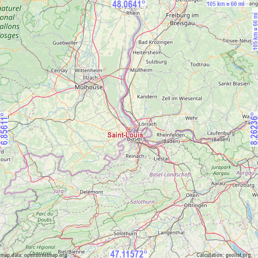
Saint-Louis GPS coordinates[2]
47° 35' 31.416" North, 7° 33' 33.228" East
| Map corner | latitude | longitude |
|---|---|---|
| Upper-left | 48.0641°, | 6.85611° |
| Center: | 47.59206°, | 7.55923° |
| Lower-right: | 47.11572°, | 8.26236° |
| Map W x H: | 105.4×105.4 km | = 65.5×65.5mi |
| max Lat: | 51.07786° ⇑47.5% North |
| Saint-Louis: | 47.59206° |
| min Lat: | ⇓52.5% South 41.3874° |
| min Long | Saint-Louis | max Long |
| -5.08615° | 7.55923° | 9.52242° |
| W 98.4%⇐ | ⇒1.6% E |
Elevation
Elevation of Saint-Louis is 245 m = 804 ft, and this is 51.3 m = 168 ft above average elevation for this country.
| Max E: |
2333 m = 7654 ft | 25.6% |
| Saint-Louis | 245 m 804 ft | |
| Avg. | 193.7 m = 635 ft | |
Min E: |
-1 m = -3 ft | 74.4% |
See also: France elevation on elevation.city.
Geographical zone
Saint-Louis is located in North temperate zone (between Tropic of Cancer and the Arctic Circle). Distance of this North polar circle is 2109.4 km =1310.7 mi to North.| Distance of | km | miles | from Saint-Louis |
|---|---|---|---|
| North Pole | 4715.3 | 2930 | to North |
| Arctic Circle | 2109.4 | 1310.7 | to North |
| Tropic Cancer | 2685.8 | 1668.9 | to South |
| Equator | 5291.7 | 3288.1 | to South |


Nearby cities:
15 places around Saint-Louis: (largest is in red/bold)
• Attenschwiller
7.7 km =4.8 mi,  248°
248°
• Bartenheim
7.6 km =4.7 mi,  307°
307°
• Blotzheim
4.8 km =3 mi,  283°
283°
• Buschwiller
5.4 km =3.4 mi,  226°
226°
• Hagenthal-le-Bas
9.6 km =6 mi,  219°
219°
• Huningue
2 km =1.2 mi,  44°
44°
• Hégenheim
4.2 km =2.6 mi, 219°
• Hésingue
3.4 km =2.1 mi,  242°
242°
• Kappelen
9.5 km =5.9 mi,  288°
288°
• Michelbach-le-Bas
7 km =4.3 mi,  270°
270°
• Neuwiller
8.3 km =5.2 mi,  204°
204°
• Ranspach-le-Bas
8.5 km =5.3 mi, 266°
• Rosenau
5.3 km =3.3 mi,  340°
340°
• Village-Neuf
1.8 km =1.1 mi,  25°
25°
• Wentzwiller
7.6 km =4.7 mi, 232°
Sources, notices
• [Note1] Compared only with cities in France existing in our database
• [Src1] Map data: © OpenStreetMap contributors (CC-BY-SA)
• [Src2] Other city data from geonames.org with taken over terms of usage.
• [Src3] Geographical zone / Annual Mean Temperature by Robert A. Rohde @ Wikipedia
