Hagenthal-le-Bas geodata
Hagenthal-le-Bas (Grand Est) is a populated place; located in France in Europe/Paris (GMT+2) time zone. With population of 1,050 people, there are 8462 cities with bigger population in this country. Compared to other cities in France, 51.6% of cities are located further ↓South; 97.8% of cities are located further ←West and 86% of cities have lower elevation than Hagenthal-le-Bas. Note1
Administrative division(s):
- Level 1: Grand Est
- Level 2: Haut-Rhin
- Level 3: Arrondissement de Mulhouse
- Level 4: Hagenthal-le-Bas


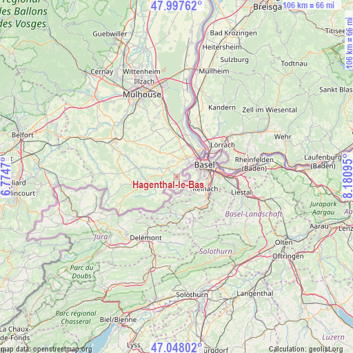
Hagenthal-le-Bas GPS coordinates[2]
47° 31' 29.892" North, 7° 28' 40.188" East
| Map corner | latitude | longitude |
|---|---|---|
| Upper-left | 47.99762°, | 6.7747° |
| Center: | 47.52497°, | 7.47783° |
| Lower-right: | 47.04802°, | 8.18095° |
| Map W x H: | 105.6×105.6 km | = 65.6×65.6mi |
| max Lat: | 51.07786° ⇑48.4% North |
| Hagenthal-le-Bas: | 47.52497° |
| min Lat: | ⇓51.6% South 41.3874° |
| min Long | Hagenthal-le-Ba | max Long |
| -5.08615° | 7.47783° | 9.52242° |
| W 97.8%⇐ | ⇒2.2% E |
Elevation
Elevation of Hagenthal-le-Bas is 360 m = 1181 ft, and this is 166.3 m = 546 ft above average elevation for this country.
| Max E: |
2333 m = 7654 ft | 14% |
| Hagenthal-le-Bas | 360 m 1181 ft | |
| Avg. | 193.7 m = 635 ft | |
Min E: |
-1 m = -3 ft | 86% |
See also: France elevation on elevation.city.
Geographical zone
Hagenthal-le-Bas is located in North temperate zone (between Tropic of Cancer and the Arctic Circle). Distance of this North polar circle is 2116.9 km =1315.4 mi to North.| Distance of | km | miles | from Hagenthal-le-Bas |
|---|---|---|---|
| North Pole | 4722.8 | 2934.6 | to North |
| Arctic Circle | 2116.9 | 1315.4 | to North |
| Tropic Cancer | 2678.4 | 1664.3 | to South |
| Equator | 5284.3 | 3283.5 | to South |


Nearby cities:
15 places around Hagenthal-le-Bas: (largest is in red/bold)
• Attenschwiller
4.8 km =3 mi,  346°
346°
• Blotzheim
8.7 km =5.4 mi,  9°
9°
• Buschwiller
4.4 km =2.7 mi,  30°
30°
• Folgensbourg
3.7 km =2.3 mi,  319°
319°
• Hégenheim
5.5 km =3.4 mi,  39°
39°
• Hésingue
6.7 km =4.2 mi, 27°
• Leymen
3.2 km =2 mi,  170°
170°
• Michelbach-le-Bas
7.6 km =4.7 mi, 353°
• Muespach-le-Haut
6.2 km =3.9 mi,  293°
293°
• Neuwiller
2.7 km =1.7 mi,  91°
91°
• Oltingue
7.5 km =4.7 mi,  239°
239°
• Ranspach-le-Bas
7.3 km =4.5 mi,  340°
340°
• Saint-Louis
9.6 km =6 mi, 39°
• Wentzwiller
2.9 km =1.8 mi,  1°
1°
• Werentzhouse
9.3 km =5.8 mi,  265°
265°
Sources, notices
• [Note1] Compared only with cities in France existing in our database
• [Src1] Map data: © OpenStreetMap contributors (CC-BY-SA)
• [Src2] Other city data from geonames.org with taken over terms of usage.
• [Src3] Geographical zone / Annual Mean Temperature by Robert A. Rohde @ Wikipedia
