Saint-Bauzille-de-Montmel geodata
Saint-Bauzille-de-Montmel (Occitanie) is a populated place; located in France in Europe/Paris (GMT+2) time zone. With population of 825 people, there are 10340 cities with bigger population in this country. Compared to other cities in France, 89.4% of cities are located further ↑North; 67.4% of cities are located further ←West and 52.6% of cities have higher elevation than Saint-Bauzille-de-Montmel. Note1
Administrative division(s):
- Level 1: Occitanie
- Level 2: Département de l'Hérault
- Level 3: Arrondissement de Lodève
- Level 4: Saint-Bauzille-de-Montmel
Current local time in Saint-Bauzille-de-Montmel:
06:03 AM, WednesdayDifference from your time zone: hours


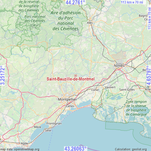
Saint-Bauzille-de-Montmel GPS coordinates[2]
43° 46' 13.872" North, 3° 57' 17.46" East
| Map corner | latitude | longitude |
|---|---|---|
| Upper-left | 44.2761°, | 3.25172° |
| Center: | 43.77052°, | 3.95485° |
| Lower-right: | 43.26063°, | 4.65797° |
| Map W x H: | 112.9×112.9 km | = 70.2×70.2mi |
| max Lat: | 51.07786° ⇑89.4% North |
| Saint-Bauzille-de-Montmel: | 43.77052° |
| min Lat: | ⇓10.6% South 41.3874° |
| min Long | Saint-Bauzille- | max Long |
| -5.08615° | 3.95485° | 9.52242° |
| W 67.4%⇐ | ⇒32.6% E |
Elevation
Elevation of Saint-Bauzille-de-Montmel is 123 m = 404 ft, and this is 70.7 m = 232 ft below average elevation for this country.
| Max E: |
2333 m = 7654 ft | 52.6% |
| Avg. | 193.7 m = 635 ft | |
| Saint-Bauzille-de-Montmel | 123 m = 404 ft | |
Min E: |
-1 m = -3 ft | 47.4% |
See also: France elevation on elevation.city.
Geographical zone
Saint-Bauzille-de-Montmel is located in North temperate zone (between Tropic of Cancer and the Arctic Circle). Distance of this Northern Tropic circle is 2260.9 km =1404.9 mi to South.| Distance of | km | miles | from Saint-Bauzille-de-Montmel |
|---|---|---|---|
| North Pole | 5140.2 | 3194 | to North |
| Arctic Circle | 2534.3 | 1574.7 | to North |
| Tropic Cancer | 2260.9 | 1404.9 | to South |
| Equator | 4866.8 | 3024.1 | to South |


Nearby cities:
15 places around Saint-Bauzille-de-Montmel: (largest is in red/bold)
• Assas
8.7 km =5.4 mi,  210°
210°
• Beaulieu
7.1 km =4.4 mi,  130°
130°
• Boisseron
10.1 km =6.3 mi,  97°
97°
• Galargues
5.4 km =3.4 mi,  88°
88°
• Montaud
2.1 km =1.3 mi,  176°
176°
• Restinclières
8.3 km =5.2 mi, 129°
• Saint-Drézéry
4.8 km =3 mi,  159°
159°
• Saint-Jean-de-Cornies
4.7 km =2.9 mi, 127°
• Saint-Mathieu-de-Tréviers
7.8 km =4.8 mi,  267°
267°
• Saint-Vincent-de-Barbeyrargues
9.4 km =5.8 mi,  221°
221°
• Sainte-Croix-de-Quintillargues
3.7 km =2.3 mi, 272°
• Saussines
8.2 km =5.1 mi, 96°
• Sussargues
7.5 km =4.7 mi,  149°
149°
• Teyran
9.7 km =6 mi,  192°
192°
• Valflaunès
7.4 km =4.6 mi,  296°
296°
Sources, notices
• [Note1] Compared only with cities in France existing in our database
• [Src1] Map data: © OpenStreetMap contributors (CC-BY-SA)
• [Src2] Other city data from geonames.org with taken over terms of usage.
• [Src3] Geographical zone / Annual Mean Temperature by Robert A. Rohde @ Wikipedia
