Valflaunès geodata
Valflaunès (Occitanie) is a populated place; located in France in Europe/Paris (GMT+2) time zone. With population of 744 people, there are 11239 cities with bigger population in this country. Compared to other cities in France, 89.1% of cities are located further ↑North; 66.7% of cities are located further ←West and 57.4% of cities have lower elevation than Valflaunès. Note1
Administrative division(s):
- Level 1: Occitanie
- Level 2: Département de l'Hérault
- Level 3: Arrondissement de Lodève
- Level 4: Valflaunès


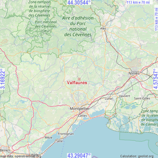
Valflaunès GPS coordinates[2]
43° 48' 0.396" North, 3° 52' 20.424" East
| Map corner | latitude | longitude |
|---|---|---|
| Upper-left | 44.30544°, | 3.16922° |
| Center: | 43.80011°, | 3.87234° |
| Lower-right: | 43.29047°, | 4.57547° |
| Map W x H: | 112.9×112.9 km | = 70.2×70.2mi |
| max Lat: | 51.07786° ⇑89.1% North |
| Valflaunès: | 43.80011° |
| min Lat: | ⇓10.9% South 41.3874° |
| min Long | Valflaunès | max Long |
| -5.08615° | 3.87234° | 9.52242° |
| W 66.7%⇐ | ⇒33.3% E |
Elevation
Elevation of Valflaunès is 159 m = 522 ft, and this is 34.7 m = 114 ft below average elevation for this country.
| Max E: |
2333 m = 7654 ft | 42.6% |
| Avg. | 193.7 m = 635 ft | |
| Valflaunès | 159 m = 522 ft | |
Min E: |
-1 m = -3 ft | 57.4% |
See also: France elevation on elevation.city.
Geographical zone
Valflaunès is located in North temperate zone (between Tropic of Cancer and the Arctic Circle). Distance of this Northern Tropic circle is 2264.2 km =1406.9 mi to South.| Distance of | km | miles | from Valflaunès |
|---|---|---|---|
| North Pole | 5136.9 | 3191.9 | to North |
| Arctic Circle | 2531.1 | 1572.8 | to North |
| Tropic Cancer | 2264.2 | 1406.9 | to South |
| Equator | 4870.1 | 3026.1 | to South |


Nearby cities:
15 places around Valflaunès: (largest is in red/bold)
• Assas
11 km =6.8 mi,  168°
168°
• Claret
7.4 km =4.6 mi,  20°
20°
• Corconne
9.6 km =6 mi,  33°
33°
• Galargues
12.4 km =7.7 mi,  104°
104°
• Les Matelles
9.2 km =5.7 mi,  210°
210°
• Montaud
8.6 km =5.3 mi,  128°
128°
• Pompignan
10.5 km =6.5 mi,  352°
352°
• Prades-le-Lez
11.4 km =7.1 mi,  183°
183°
• Saint-Bauzille-de-Montmel
7.4 km =4.6 mi,  116°
116°
• Saint-Drézéry
11.4 km =7.1 mi, 133°
• Saint-Jean-de-Cornies
12.1 km =7.5 mi, 120°
• Saint-Martin-de-Londres
11.4 km =7.1 mi,  264°
264°
• Saint-Mathieu-de-Tréviers
3.8 km =2.4 mi,  197°
197°
• Saint-Vincent-de-Barbeyrargues
10.4 km =6.5 mi, 177°
• Sainte-Croix-de-Quintillargues
4.3 km =2.7 mi,  137°
137°
Sources, notices
• [Note1] Compared only with cities in France existing in our database
• [Src1] Map data: © OpenStreetMap contributors (CC-BY-SA)
• [Src2] Other city data from geonames.org with taken over terms of usage.
• [Src3] Geographical zone / Annual Mean Temperature by Robert A. Rohde @ Wikipedia
