Rochemaure geodata
Rochemaure (Auvergne-Rhône-Alpes) is a populated place; located in France in Europe/Paris (GMT+2) time zone. With population of 1,989 people, there are 4815 cities with bigger population in this country. Compared to other cities in France, 82.9% of cities are located further ↑North; 73.8% of cities are located further ←West and 71.9% of cities have higher elevation than Rochemaure. Note1
Administrative division(s):
- Level 1: Auvergne-Rhône-Alpes
- Level 2: Département de l'Ardèche
- Level 3: Arrondissement de Privas
- Level 4: Rochemaure


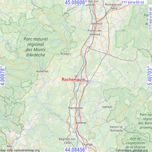
Rochemaure GPS coordinates[2]
44° 35' 14.892" North, 4° 42' 14.076" East
| Map corner | latitude | longitude |
|---|---|---|
| Upper-left | 45.08606°, | 4.00078° |
| Center: | 44.58747°, | 4.70391° |
| Lower-right: | 44.08456°, | 5.40703° |
| Map W x H: | 111.4×111.4 km | = 69.2×69.2mi |
| max Lat: | 51.07786° ⇑82.9% North |
| Rochemaure: | 44.58747° |
| min Lat: | ⇓17.1% South 41.3874° |
| min Long | Rochemaure | max Long |
| -5.08615° | 4.70391° | 9.52242° |
| W 73.8%⇐ | ⇒26.2% E |
Elevation
Elevation of Rochemaure is 74 m = 243 ft, and this is 119.7 m = 393 ft below average elevation for this country.
| Max E: |
2333 m = 7654 ft | 71.9% |
| Avg. | 193.7 m = 635 ft | |
| Rochemaure | 74 m = 243 ft | |
Min E: |
-1 m = -3 ft | 28.1% |
See also: France elevation on elevation.city.
Geographical zone
Rochemaure is located in North temperate zone (between Tropic of Cancer and the Arctic Circle). Distance of this Northern Tropic circle is 2351.7 km =1461.3 mi to South.| Distance of | km | miles | from Rochemaure |
|---|---|---|---|
| North Pole | 5049.4 | 3137.6 | to North |
| Arctic Circle | 2443.5 | 1518.3 | to North |
| Tropic Cancer | 2351.7 | 1461.3 | to South |
| Equator | 4957.7 | 3080.6 | to South |


Nearby cities:
15 places around Rochemaure: (largest is in red/bold)
• Alba-la-Romaine
9.1 km =5.7 mi,  246°
246°
• Ancône
2 km =1.2 mi,  111°
111°
• Châteauneuf-du-Rhône
11 km =6.8 mi,  174°
174°
• Cruas
9 km =5.6 mi,  31°
31°
• La Coucourde
9.3 km =5.8 mi,  42°
42°
• La Laupie
11.4 km =7.1 mi,  81°
81°
• Le Teil
5 km =3.1 mi,  200°
200°
• Meysse
3 km =1.9 mi, 30°
• Montboucher-sur-Jabron
8.8 km =5.5 mi,  117°
117°
• Montélimar
5.4 km =3.4 mi,  132°
132°
• Saint-Lager-Bressac
11.7 km =7.3 mi,  2°
2°
• Saint-Marcel-lès-Sauzet
8.1 km =5 mi, 82°
• Saint-Vincent-de-Barrès
8.3 km =5.2 mi, 3°
• Sauzet
9.4 km =5.8 mi, 78°
• Savasse
6 km =3.7 mi,  71°
71°
Sources, notices
• [Note1] Compared only with cities in France existing in our database
• [Src1] Map data: © OpenStreetMap contributors (CC-BY-SA)
• [Src2] Other city data from geonames.org with taken over terms of usage.
• [Src3] Geographical zone / Annual Mean Temperature by Robert A. Rohde @ Wikipedia
