Rives geodata
Rives (Auvergne-Rhône-Alpes) is a populated place; located in France in Europe/Paris (GMT+2) time zone. With population of 6,067 people, there are 1629 cities with bigger population in this country. Compared to other cities in France, 75.8% of cities are located further ↑North; 82.9% of cities are located further ←West and 85.5% of cities have lower elevation than Rives. Note1
Administrative division(s):
- Level 1: Auvergne-Rhône-Alpes
- Level 2: Département de l'Isère
- Level 3: Arrondissement de Grenoble
- Level 4: Rives


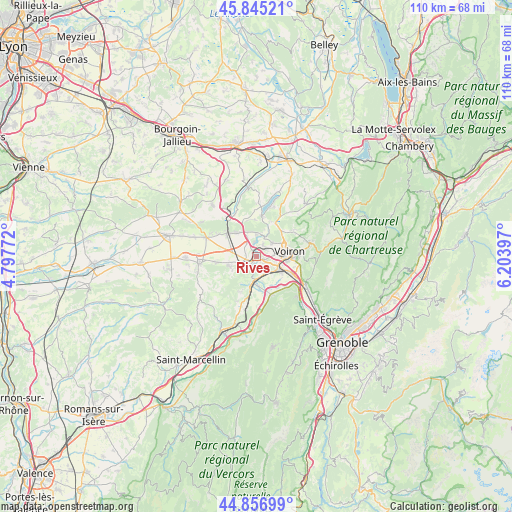
Rives GPS coordinates[2]
45° 21' 11.736" North, 5° 30' 3.024" East
| Map corner | latitude | longitude |
|---|---|---|
| Upper-left | 45.84521°, | 4.79772° |
| Center: | 45.35326°, | 5.50084° |
| Lower-right: | 44.85699°, | 6.20397° |
| Map W x H: | 109.9×109.9 km | = 68.3×68.3mi |
| max Lat: | 51.07786° ⇑75.8% North |
| Rives: | 45.35326° |
| min Lat: | ⇓24.2% South 41.3874° |
| min Long | Rives | max Long |
| -5.08615° | 5.50084° | 9.52242° |
| W 82.9%⇐ | ⇒17.1% E |
Elevation
Elevation of Rives is 353 m = 1158 ft, and this is 159.3 m = 523 ft above average elevation for this country.
| Max E: |
2333 m = 7654 ft | 14.5% |
| Rives | 353 m 1158 ft | |
| Avg. | 193.7 m = 635 ft | |
Min E: |
-1 m = -3 ft | 85.5% |
See also: France elevation on elevation.city.
Geographical zone
Rives is located in North temperate zone (between Tropic of Cancer and the Arctic Circle). Distance of this North polar circle is 2358.4 km =1465.4 mi to North.| Distance of | km | miles | from Rives |
|---|---|---|---|
| North Pole | 4964.3 | 3084.7 | to North |
| Arctic Circle | 2358.4 | 1465.4 | to North |
| Tropic Cancer | 2436.9 | 1514.2 | to South |
| Equator | 5042.8 | 3133.4 | to South |


Nearby cities:
15 places around Rives: (largest is in red/bold)
• Apprieu
4.7 km =2.9 mi,  359°
359°
• Beaucroissant
2.6 km =1.6 mi,  243°
243°
• Charnècles
2.4 km =1.5 mi,  115°
115°
• Colombe
6.4 km =4 mi,  325°
325°
• Izeaux
6.3 km =3.9 mi,  250°
250°
• La Murette
4.3 km =2.7 mi,  48°
48°
• Moirans
4.8 km =3 mi, 120°
• Renage
2.4 km =1.5 mi,  203°
203°
• Réaumont
2.3 km =1.4 mi, 52°
• Saint-Blaise-du-Buis
3 km =1.9 mi,  26°
26°
• Saint-Cassien
3.7 km =2.3 mi,  83°
83°
• Saint-Jean-de-Moirans
6.7 km =4.2 mi,  97°
97°
• Tullins
5.7 km =3.5 mi,  187°
187°
• Voiron
6.7 km =4.2 mi, 79°
• Vourey
3.8 km =2.4 mi,  157°
157°
Sources, notices
• [Note1] Compared only with cities in France existing in our database
• [Src1] Map data: © OpenStreetMap contributors (CC-BY-SA)
• [Src2] Other city data from geonames.org with taken over terms of usage.
• [Src3] Geographical zone / Annual Mean Temperature by Robert A. Rohde @ Wikipedia
