Izeaux geodata
Izeaux (Auvergne-Rhône-Alpes) is a populated place; located in France in Europe/Paris (GMT+2) time zone. With population of 1,954 people, there are 4899 cities with bigger population in this country. Compared to other cities in France, 76% of cities are located further ↑North; 82.2% of cities are located further ←West and 90% of cities have lower elevation than Izeaux. Note1
Administrative division(s):
- Level 1: Auvergne-Rhône-Alpes
- Level 2: Département de l'Isère
- Level 3: Arrondissement de Grenoble
- Level 4: Izeaux


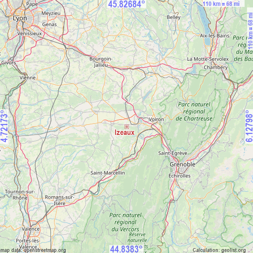
Izeaux GPS coordinates[2]
45° 20' 5.028" North, 5° 25' 29.496" East
| Map corner | latitude | longitude |
|---|---|---|
| Upper-left | 45.82684°, | 4.72173° |
| Center: | 45.33473°, | 5.42486° |
| Lower-right: | 44.8383°, | 6.12798° |
| Map W x H: | 109.9×109.9 km | = 68.3×68.3mi |
| max Lat: | 51.07786° ⇑76% North |
| Izeaux: | 45.33473° |
| min Lat: | ⇓24% South 41.3874° |
| min Long | Izeaux | max Long |
| -5.08615° | 5.42486° | 9.52242° |
| W 82.2%⇐ | ⇒17.8% E |
Elevation
Elevation of Izeaux is 425 m = 1394 ft, and this is 231.3 m = 759 ft above average elevation for this country.
| Max E: |
2333 m = 7654 ft | 10% |
| Izeaux | 425 m 1394 ft | |
| Avg. | 193.7 m = 635 ft | |
Min E: |
-1 m = -3 ft | 90% |
See also: France elevation on elevation.city.
Geographical zone
Izeaux is located in North temperate zone (between Tropic of Cancer and the Arctic Circle). Distance of this North polar circle is 2360.4 km =1466.7 mi to North.| Distance of | km | miles | from Izeaux |
|---|---|---|---|
| North Pole | 4966.3 | 3085.9 | to North |
| Arctic Circle | 2360.4 | 1466.7 | to North |
| Tropic Cancer | 2434.8 | 1512.9 | to South |
| Equator | 5040.7 | 3132.1 | to South |


Nearby cities:
15 places around Izeaux: (largest is in red/bold)
• Apprieu
9 km =5.6 mi,  40°
40°
• Beaucroissant
3.7 km =2.3 mi,  76°
76°
• Bévenais
7.3 km =4.5 mi,  340°
340°
• Charnècles
8.1 km =5 mi, 82°
• Colombe
7.6 km =4.7 mi,  17°
17°
• La Frette
7.9 km =4.9 mi,  319°
319°
• Le Grand-Lemps
6.9 km =4.3 mi,  356°
356°
• Renage
5 km =3.1 mi,  91°
91°
• Rives
6.3 km =3.9 mi,  70°
70°
• Réaumont
8.5 km =5.3 mi, 66°
• Saint-Blaise-du-Buis
8.7 km =5.4 mi,  56°
56°
• Saint-Étienne-de-Saint-Geoirs
6.1 km =3.8 mi,  274°
274°
• Sillans
3 km =1.9 mi,  287°
287°
• Tullins
6.3 km =3.9 mi,  124°
124°
• Vourey
7.5 km =4.7 mi,  101°
101°
Sources, notices
• [Note1] Compared only with cities in France existing in our database
• [Src1] Map data: © OpenStreetMap contributors (CC-BY-SA)
• [Src2] Other city data from geonames.org with taken over terms of usage.
• [Src3] Geographical zone / Annual Mean Temperature by Robert A. Rohde @ Wikipedia
