Pontenx-les-Forges geodata
Pontenx-les-Forges (Nouvelle-Aquitaine) is a populated place; located in France in Europe/Paris (GMT+2) time zone. With population of 1,174 people, there are 7680 cities with bigger population in this country. Compared to other cities in France, 85.2% of cities are located further ↑North; 89.4% of cities are located further →East and 90.3% of cities have higher elevation than Pontenx-les-Forges. Note1
Administrative division(s):
- Level 1: Nouvelle-Aquitaine
- Level 2: Landes
- Level 3: Arrondissement de Mont-de-Marsan
- Level 4: Pontenx-les-Forges


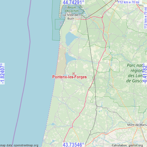
Pontenx-les-Forges GPS coordinates[2]
44° 14' 28.824" North, 1° 7' 15.42" West
| Map corner | latitude | longitude |
|---|---|---|
| Upper-left | 44.74291°, | -1.82407° |
| Center: | 44.24134°, | -1.12095° |
| Lower-right: | 43.73546°, | -0.41782° |
| Map W x H: | 112×112 km | = 69.6×69.6mi |
| max Lat: | 51.07786° ⇑85.2% North |
| Pontenx-les-Forges: | 44.24134° |
| min Lat: | ⇓14.8% South 41.3874° |
| min Long | Pontenx-les-For | max Long |
| -5.08615° | -1.12095° | 9.52242° |
| W 10.6%⇐ | ⇒89.4% E |
Elevation
Elevation of Pontenx-les-Forges is 29 m = 95 ft, and this is 164.7 m = 540 ft below average elevation for this country.
| Max E: |
2333 m = 7654 ft | 90.3% |
| Avg. | 193.7 m = 635 ft | |
| Pontenx-les-Forges | 29 m = 95 ft | |
Min E: |
-1 m = -3 ft | 9.7% |
See also: France elevation on elevation.city.
Geographical zone
Pontenx-les-Forges is located in North temperate zone (between Tropic of Cancer and the Arctic Circle). Distance of this Northern Tropic circle is 2313.3 km =1437.4 mi to South.| Distance of | km | miles | from Pontenx-les-Forges |
|---|---|---|---|
| North Pole | 5087.9 | 3161.5 | to North |
| Arctic Circle | 2482 | 1542.2 | to North |
| Tropic Cancer | 2313.3 | 1437.4 | to South |
| Equator | 4919.2 | 3056.6 | to South |


Nearby cities:
15 places around Pontenx-les-Forges: (largest is in red/bold)
• Aureilhan
7.1 km =4.4 mi,  250°
250°
• Bias
13.2 km =8.2 mi,  215°
215°
• Biscarrosse
17.4 km =10.8 mi,  347°
347°
• Escource
11.1 km =6.9 mi,  140°
140°
• Labouheyre
16.3 km =10.1 mi,  101°
101°
• Lit-et-Mixe
25.5 km =15.8 mi,  204°
204°
• Mimizan
9.7 km =6 mi,  242°
242°
• Mézos
18.7 km =11.6 mi,  190°
190°
• Onesse-Laharie
20.4 km =12.7 mi,  168°
168°
• Parentis-en-Born
13 km =8.1 mi,  17°
17°
• Pissos
28.2 km =17.5 mi,  74°
74°
• Saint-Julien-en-Born
21.5 km =13.4 mi, 202°
• Sainte-Eulalie-en-Born
6.2 km =3.9 mi,  306°
306°
• Sanguinet
27.1 km =16.8 mi,  7°
7°
• Ychoux
16.6 km =10.3 mi,  54°
54°
Sources, notices
• [Note1] Compared only with cities in France existing in our database
• [Src1] Map data: © OpenStreetMap contributors (CC-BY-SA)
• [Src2] Other city data from geonames.org with taken over terms of usage.
• [Src3] Geographical zone / Annual Mean Temperature by Robert A. Rohde @ Wikipedia
