Aureilhan geodata
Aureilhan (Nouvelle-Aquitaine) is a populated place; located in France in Europe/Paris (GMT+2) time zone. With population of 703 people, there are 11764 cities with bigger population in this country. Compared to other cities in France, 85.4% of cities are located further ↑North; 90% of cities are located further →East and 97% of cities have higher elevation than Aureilhan. Note1
Administrative division(s):
- Level 1: Nouvelle-Aquitaine
- Level 2: Landes
- Level 3: Arrondissement de Mont-de-Marsan
- Level 4: Aureilhan


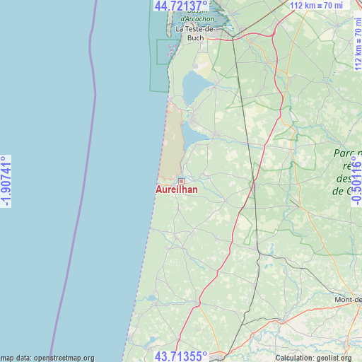
Aureilhan GPS coordinates[2]
44° 13' 10.632" North, 1° 12' 15.408" West
| Map corner | latitude | longitude |
|---|---|---|
| Upper-left | 44.72137°, | -1.90741° |
| Center: | 44.21962°, | -1.20428° |
| Lower-right: | 43.71355°, | -0.50116° |
| Map W x H: | 112.1×112.1 km | = 69.7×69.7mi |
| max Lat: | 51.07786° ⇑85.4% North |
| Aureilhan: | 44.21962° |
| min Lat: | ⇓14.6% South 41.3874° |
| min Long | Aureilhan | max Long |
| -5.08615° | -1.20428° | 9.52242° |
| W 10%⇐ | ⇒90% E |
Elevation
Elevation of Aureilhan is 11 m = 36 ft, and this is 182.7 m = 599 ft below average elevation for this country.
| Max E: |
2333 m = 7654 ft | 97% |
| Avg. | 193.7 m = 635 ft | |
| Aureilhan | 11 m = 36 ft | |
Min E: |
-1 m = -3 ft | 3% |
See also: France elevation on elevation.city.
Geographical zone
Aureilhan is located in North temperate zone (between Tropic of Cancer and the Arctic Circle). Distance of this Northern Tropic circle is 2310.8 km =1435.9 mi to South.| Distance of | km | miles | from Aureilhan |
|---|---|---|---|
| North Pole | 5090.3 | 3163 | to North |
| Arctic Circle | 2484.4 | 1543.7 | to North |
| Tropic Cancer | 2310.8 | 1435.9 | to South |
| Equator | 4916.8 | 3055.2 | to South |


Nearby cities:
15 places around Aureilhan: (largest is in red/bold)
• Bias
8.4 km =5.2 mi,  187°
187°
• Biscarrosse
19.7 km =12.2 mi,  8°
8°
• Escource
15 km =9.3 mi,  114°
114°
• Labouheyre
22.6 km =14 mi,  91°
91°
• Lesperon
29.1 km =18.1 mi,  162°
162°
• Lit-et-Mixe
21.1 km =13.1 mi, 190°
• Mimizan
2.9 km =1.8 mi,  222°
222°
• Morcenx
30.9 km =19.2 mi,  131°
131°
• Mézos
16.3 km =10.1 mi,  168°
168°
• Onesse-Laharie
20.6 km =12.8 mi,  148°
148°
• Parentis-en-Born
18.2 km =11.3 mi,  35°
35°
• Pontenx-les-Forges
7.1 km =4.4 mi,  70°
70°
• Saint-Julien-en-Born
17.5 km =10.9 mi, 185°
• Sainte-Eulalie-en-Born
6.4 km =4 mi,  15°
15°
• Ychoux
23.5 km =14.6 mi,  58°
58°
Sources, notices
• [Note1] Compared only with cities in France existing in our database
• [Src1] Map data: © OpenStreetMap contributors (CC-BY-SA)
• [Src2] Other city data from geonames.org with taken over terms of usage.
• [Src3] Geographical zone / Annual Mean Temperature by Robert A. Rohde @ Wikipedia
