Poliénas geodata
Poliénas (Auvergne-Rhône-Alpes) is a populated place; located in France in Europe/Paris (GMT+2) time zone. With population of 992 people, there are 8887 cities with bigger population in this country. Compared to other cities in France, 76.9% of cities are located further ↑North; 82.7% of cities are located further ←West and 63.8% of cities have lower elevation than Poliénas. Note1
Administrative division(s):
- Level 1: Auvergne-Rhône-Alpes
- Level 2: Département de l'Isère
- Level 3: Arrondissement de Grenoble
- Level 4: Poliénas


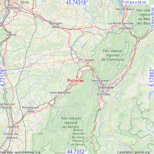
Poliénas GPS coordinates[2]
45° 15' 8.46" North, 5° 28' 29.676" East
| Map corner | latitude | longitude |
|---|---|---|
| Upper-left | 45.74518°, | 4.77178° |
| Center: | 45.25235°, | 5.47491° |
| Lower-right: | 44.7552°, | 6.17803° |
| Map W x H: | 110.1×110.1 km | = 68.4×68.4mi |
| max Lat: | 51.07786° ⇑76.9% North |
| Poliénas: | 45.25235° |
| min Lat: | ⇓23.1% South 41.3874° |
| min Long | Poliénas | max Long |
| -5.08615° | 5.47491° | 9.52242° |
| W 82.7%⇐ | ⇒17.3% E |
Elevation
Elevation of Poliénas is 188 m = 617 ft, and this is 5.7 m = 19 ft below average elevation for this country.
| Max E: |
2333 m = 7654 ft | 36.2% |
| Avg. | 193.7 m = 635 ft | |
| Poliénas | 188 m = 617 ft | |
Min E: |
-1 m = -3 ft | 63.8% |
See also: France elevation on elevation.city.
Geographical zone
Poliénas is located in North temperate zone (between Tropic of Cancer and the Arctic Circle). Distance of this North polar circle is 2369.6 km =1472.4 mi to North.| Distance of | km | miles | from Poliénas |
|---|---|---|---|
| North Pole | 4975.5 | 3091.6 | to North |
| Arctic Circle | 2369.6 | 1472.4 | to North |
| Tropic Cancer | 2425.7 | 1507.3 | to South |
| Equator | 5031.6 | 3126.5 | to South |


Nearby cities:
15 places around Poliénas: (largest is in red/bold)
• Autrans
10 km =6.2 mi,  147°
147°
• Beaucroissant
10.1 km =6.3 mi,  358°
358°
• Beaulieu
10.3 km =6.4 mi,  217°
217°
• Charnècles
11 km =6.8 mi,  22°
22°
• Cognin-les-Gorges
10.4 km =6.5 mi,  208°
208°
• Izeaux
10 km =6.2 mi,  336°
336°
• La Rivière
3.1 km =1.9 mi,  127°
127°
• Moirans
10.8 km =6.7 mi,  35°
35°
• Montaud
6.8 km =4.2 mi,  80°
80°
• Renage
9.1 km =5.7 mi,  6°
6°
• Rovon
6 km =3.7 mi,  192°
192°
• Saint-Quentin-sur-Isère
6.2 km =3.9 mi,  62°
62°
• Tullins
5.7 km =3.5 mi, 12°
• Vinay
7.3 km =4.5 mi,  227°
227°
• Vourey
8.5 km =5.3 mi, 24°
Sources, notices
• [Note1] Compared only with cities in France existing in our database
• [Src1] Map data: © OpenStreetMap contributors (CC-BY-SA)
• [Src2] Other city data from geonames.org with taken over terms of usage.
• [Src3] Geographical zone / Annual Mean Temperature by Robert A. Rohde @ Wikipedia
