Plaintel geodata
Plaintel (Brittany) is a populated place; located in France in Europe/Paris (GMT+2) time zone. With population of 3,693 people, there are 2663 cities with bigger population in this country. Compared to other cities in France, 66.5% of cities are located further ↓South; 96.9% of cities are located further →East and 67.4% of cities have lower elevation than Plaintel. Note1
Administrative division(s):
- Level 1: Brittany
- Level 2: Département des Côtes-d’Armor
- Level 3: Arrondissement de Saint-Brieuc
- Level 4: Plaintel


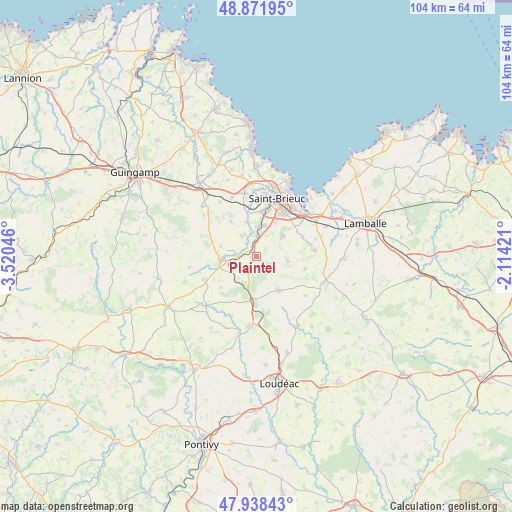
Plaintel GPS coordinates[2]
48° 24' 26.388" North, 2° 49' 2.388" West
| Map corner | latitude | longitude |
|---|---|---|
| Upper-left | 48.87195°, | -3.52046° |
| Center: | 48.40733°, | -2.81733° |
| Lower-right: | 47.93843°, | -2.11421° |
| Map W x H: | 103.8×103.8 km | = 64.5×64.5mi |
| max Lat: | 51.07786° ⇑33.5% North |
| Plaintel: | 48.40733° |
| min Lat: | ⇓66.5% South 41.3874° |
| min Long | Plaintel | max Long |
| -5.08615° | -2.81733° | 9.52242° |
| W 3.1%⇐ | ⇒96.9% E |
Elevation
Elevation of Plaintel is 206 m = 676 ft, and this is 12.3 m = 40 ft above average elevation for this country.
| Max E: |
2333 m = 7654 ft | 32.6% |
| Plaintel | 206 m 676 ft | |
| Avg. | 193.7 m = 635 ft | |
Min E: |
-1 m = -3 ft | 67.4% |
See also: France elevation on elevation.city.
Geographical zone
Plaintel is located in North temperate zone (between Tropic of Cancer and the Arctic Circle). Distance of this North polar circle is 2018.8 km =1254.4 mi to North.| Distance of | km | miles | from Plaintel |
|---|---|---|---|
| North Pole | 4624.7 | 2873.7 | to North |
| Arctic Circle | 2018.8 | 1254.4 | to North |
| Tropic Cancer | 2776.5 | 1725.2 | to South |
| Equator | 5382.4 | 3344.5 | to South |


Nearby cities:
15 places around Plaintel: (largest is in red/bold)
• Allineuc
11.5 km =7.1 mi,  200°
200°
• Hénon
10.2 km =6.3 mi,  104°
104°
• La Méaugon
10.3 km =6.4 mi,  351°
351°
• Langueux
12.2 km =7.6 mi,  36°
36°
• Le Fœil
7.9 km =4.9 mi,  291°
291°
• Plaine-Haute
4.9 km =3 mi,  326°
326°
• Ploufragan
9.5 km =5.9 mi,  10°
10°
• Plédran
6.8 km =4.2 mi,  50°
50°
• Plœuc-sur-Lié
8.1 km =5 mi,  142°
142°
• Quessoy
11.7 km =7.3 mi,  81°
81°
• Quintin
6.9 km =4.3 mi,  266°
266°
• Saint-Brandan
4.3 km =2.7 mi,  243°
243°
• Saint-Carreuc
6.5 km =4 mi, 98°
• Saint-Donan
8.5 km =5.3 mi,  324°
324°
• Saint-Julien
4.9 km =3 mi,  4°
4°
Sources, notices
• [Note1] Compared only with cities in France existing in our database
• [Src1] Map data: © OpenStreetMap contributors (CC-BY-SA)
• [Src2] Other city data from geonames.org with taken over terms of usage.
• [Src3] Geographical zone / Annual Mean Temperature by Robert A. Rohde @ Wikipedia
