Saint-Carreuc geodata
Saint-Carreuc (Brittany) is a populated place; located in France in Europe/Paris (GMT+2) time zone. With population of 1,274 people, there are 7154 cities with bigger population in this country. Compared to other cities in France, 66.3% of cities are located further ↓South; 96.7% of cities are located further →East and 65.4% of cities have lower elevation than Saint-Carreuc. Note1
Administrative division(s):
- Level 1: Brittany
- Level 2: Département des Côtes-d’Armor
- Level 3: Arrondissement de Saint-Brieuc
- Level 4: Saint-Carreuc


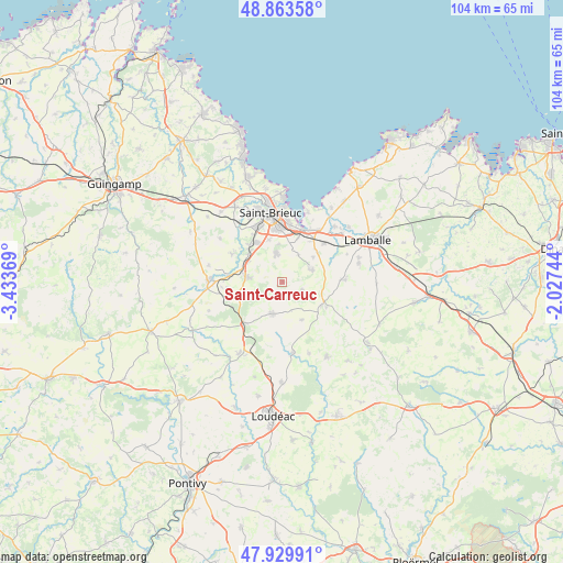
Saint-Carreuc GPS coordinates[2]
48° 23' 56.004" North, 2° 43' 50.016" West
| Map corner | latitude | longitude |
|---|---|---|
| Upper-left | 48.86358°, | -3.43369° |
| Center: | 48.39889°, | -2.73056° |
| Lower-right: | 47.92991°, | -2.02744° |
| Map W x H: | 103.8×103.8 km | = 64.5×64.5mi |
| max Lat: | 51.07786° ⇑33.7% North |
| Saint-Carreuc: | 48.39889° |
| min Lat: | ⇓66.3% South 41.3874° |
| min Long | Saint-Carreuc | max Long |
| -5.08615° | -2.73056° | 9.52242° |
| W 3.3%⇐ | ⇒96.7% E |
Elevation
Elevation of Saint-Carreuc is 196 m = 643 ft, and this is 2.3 m = 8 ft above average elevation for this country.
| Max E: |
2333 m = 7654 ft | 34.6% |
| Saint-Carreuc | 196 m 643 ft | |
| Avg. | 193.7 m = 635 ft | |
Min E: |
-1 m = -3 ft | 65.4% |
See also: France elevation on elevation.city.
Geographical zone
Saint-Carreuc is located in North temperate zone (between Tropic of Cancer and the Arctic Circle). Distance of this North polar circle is 2019.7 km =1255 mi to North.| Distance of | km | miles | from Saint-Carreuc |
|---|---|---|---|
| North Pole | 4625.6 | 2874.2 | to North |
| Arctic Circle | 2019.7 | 1255 | to North |
| Tropic Cancer | 2775.5 | 1724.6 | to South |
| Equator | 5381.5 | 3343.9 | to South |


Nearby cities:
15 places around Saint-Carreuc: (largest is in red/bold)
• Gausson
11.2 km =7 mi,  188°
188°
• Hénon
3.8 km =2.4 mi,  114°
114°
• Langueux
10.7 km =6.6 mi,  4°
4°
• Moncontour
8.4 km =5.2 mi,  121°
121°
• Plaine-Haute
10.4 km =6.5 mi,  299°
299°
• Plaintel
6.5 km =4 mi,  278°
278°
• Plédran
5.4 km =3.4 mi,  347°
347°
• Plémy
7.8 km =4.8 mi,  152°
152°
• Plœuc-sur-Lié
5.6 km =3.5 mi, 194°
• Pommeret
10.5 km =6.5 mi,  46°
46°
• Quessoy
5.8 km =3.6 mi,  63°
63°
• Saint-Brandan
10.2 km =6.3 mi,  264°
264°
• Saint-Julien
8.4 km =5.2 mi,  314°
314°
• Trédaniel
9.4 km =5.8 mi, 118°
• Yffiniac
10.3 km =6.4 mi,  22°
22°
Sources, notices
• [Note1] Compared only with cities in France existing in our database
• [Src1] Map data: © OpenStreetMap contributors (CC-BY-SA)
• [Src2] Other city data from geonames.org with taken over terms of usage.
• [Src3] Geographical zone / Annual Mean Temperature by Robert A. Rohde @ Wikipedia
