Pecquencourt geodata
Pecquencourt (Hauts-de-France) is a populated place; located in France in Europe/Paris (GMT+2) time zone. With population of 6,703 people, there are 1479 cities with bigger population in this country. Compared to other cities in France, 96.3% of cities are located further ↓South; 60.8% of cities are located further ←West and 93.9% of cities have higher elevation than Pecquencourt. Note1
Administrative division(s):
- Level 1: Hauts-de-France
- Level 2: Nord
- Level 3: Arrondissement de Douai
- Level 4: Pecquencourt


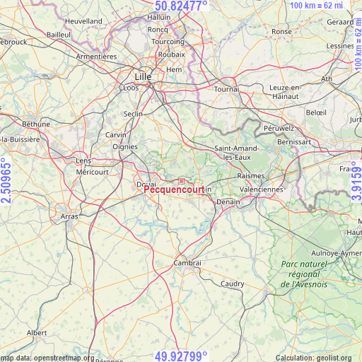
Pecquencourt GPS coordinates[2]
50° 22' 42.6" North, 3° 12' 45.972" East
| Map corner | latitude | longitude |
|---|---|---|
| Upper-left | 50.82477°, | 2.50965° |
| Center: | 50.3785°, | 3.21277° |
| Lower-right: | 49.92799°, | 3.9159° |
| Map W x H: | 99.7×99.7 km | = 62×62mi |
| max Lat: | 51.07786° ⇑3.7% North |
| Pecquencourt: | 50.3785° |
| min Lat: | ⇓96.3% South 41.3874° |
| min Long | Pecquencourt | max Long |
| -5.08615° | 3.21277° | 9.52242° |
| W 60.8%⇐ | ⇒39.2% E |
Elevation
Elevation of Pecquencourt is 20 m = 66 ft, and this is 173.7 m = 570 ft below average elevation for this country.
| Max E: |
2333 m = 7654 ft | 93.9% |
| Avg. | 193.7 m = 635 ft | |
| Pecquencourt | 20 m = 66 ft | |
Min E: |
-1 m = -3 ft | 6.1% |
See also: France elevation on elevation.city.
Geographical zone
Pecquencourt is located in North temperate zone (between Tropic of Cancer and the Arctic Circle). Distance of this North polar circle is 1799.6 km =1118.2 mi to North.| Distance of | km | miles | from Pecquencourt |
|---|---|---|---|
| North Pole | 4405.5 | 2737.4 | to North |
| Arctic Circle | 1799.6 | 1118.2 | to North |
| Tropic Cancer | 2995.6 | 1861.4 | to South |
| Equator | 5601.6 | 3480.7 | to South |


Nearby cities:
15 places around Pecquencourt: (largest is in red/bold)
• Anhiers
5.2 km =3.2 mi,  308°
308°
• Auberchicourt
5.2 km =3.2 mi,  163°
163°
• Bruille-lez-Marchiennes
3 km =1.9 mi,  131°
131°
• Flines-lez-Raches
4.7 km =2.9 mi,  333°
333°
• Guesnain
5.5 km =3.4 mi,  234°
234°
• Lallaing
3.3 km =2.1 mi,  292°
292°
• Lewarde
5.2 km =3.2 mi,  217°
217°
• Loffre
3.8 km =2.4 mi, 230°
• Marchiennes
5.5 km =3.4 mi,  64°
64°
• Masny
3.5 km =2.2 mi,  193°
193°
• Montigny-en-Ostrevent
2.5 km =1.6 mi,  237°
237°
• Rieulay
2.8 km =1.7 mi,  89°
89°
• Somain
5.3 km =3.3 mi,  113°
113°
• Vred
2.2 km =1.4 mi,  34°
34°
• Écaillon
3.1 km =1.9 mi,  174°
174°
Sources, notices
• [Note1] Compared only with cities in France existing in our database
• [Src1] Map data: © OpenStreetMap contributors (CC-BY-SA)
• [Src2] Other city data from geonames.org with taken over terms of usage.
• [Src3] Geographical zone / Annual Mean Temperature by Robert A. Rohde @ Wikipedia
