Guesnain geodata
Guesnain (Hauts-de-France) is a populated place; located in France in Europe/Paris (GMT+2) time zone. With population of 4,987 people, there are 1989 cities with bigger population in this country. Compared to other cities in France, 96% of cities are located further ↓South; 59.9% of cities are located further ←West and 92.7% of cities have higher elevation than Guesnain. Note1
Administrative division(s):
- Level 1: Hauts-de-France
- Level 2: Nord
- Level 3: Arrondissement de Douai
- Level 4: Guesnain


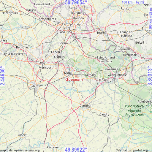
Guesnain GPS coordinates[2]
50° 21' 0" North, 3° 9' 0" East
| Map corner | latitude | longitude |
|---|---|---|
| Upper-left | 50.79654°, | 2.44688° |
| Center: | 50.35°, | 3.15° |
| Lower-right: | 49.89922°, | 3.85313° |
| Map W x H: | 99.8×99.8 km | = 62×62mi |
| max Lat: | 51.07786° ⇑4% North |
| Guesnain: | 50.35° |
| min Lat: | ⇓96% South 41.3874° |
| min Long | Guesnain | max Long |
| -5.08615° | 3.15° | 9.52242° |
| W 59.9%⇐ | ⇒40.1% E |
Elevation
Elevation of Guesnain is 23 m = 75 ft, and this is 170.7 m = 560 ft below average elevation for this country.
| Max E: |
2333 m = 7654 ft | 92.7% |
| Avg. | 193.7 m = 635 ft | |
| Guesnain | 23 m = 75 ft | |
Min E: |
-1 m = -3 ft | 7.3% |
See also: France elevation on elevation.city.
Geographical zone
Guesnain is located in North temperate zone (between Tropic of Cancer and the Arctic Circle). Distance of this North polar circle is 1802.8 km =1120.2 mi to North.| Distance of | km | miles | from Guesnain |
|---|---|---|---|
| North Pole | 4408.7 | 2739.4 | to North |
| Arctic Circle | 1802.8 | 1120.2 | to North |
| Tropic Cancer | 2992.5 | 1859.5 | to South |
| Equator | 5598.4 | 3478.7 | to South |


Nearby cities:
15 places around Guesnain: (largest is in red/bold)
• Cantin
4.8 km =3 mi,  199°
199°
• Dechy
2.4 km =1.5 mi,  270°
270°
• Douai
5.5 km =3.4 mi,  294°
294°
• Erchin
3.8 km =2.4 mi,  161°
161°
• Gœulzin
5.1 km =3.2 mi,  223°
223°
• Lallaing
4.7 km =2.9 mi,  17°
17°
• Lewarde
1.6 km =1 mi,  126°
126°
• Loffre
1.7 km =1.1 mi,  63°
63°
• Masny
3.7 km =2.3 mi,  93°
93°
• Montigny-en-Ostrevent
3 km =1.9 mi,  51°
51°
• Pecquencourt
5.5 km =3.4 mi, 54°
• Sin-le-Noble
1.9 km =1.2 mi,  313°
313°
• Villers-au-Tertre
5.8 km =3.6 mi, 157°
• Waziers
4.8 km =3 mi,  328°
328°
• Écaillon
4.7 km =2.9 mi, 89°
Sources, notices
• [Note1] Compared only with cities in France existing in our database
• [Src1] Map data: © OpenStreetMap contributors (CC-BY-SA)
• [Src2] Other city data from geonames.org with taken over terms of usage.
• [Src3] Geographical zone / Annual Mean Temperature by Robert A. Rohde @ Wikipedia
