Nousty geodata
Nousty (Nouvelle-Aquitaine) is a populated place; located in France in Europe/Paris (GMT+2) time zone. With population of 1,020 people, there are 8683 cities with bigger population in this country. Compared to other cities in France, 96.4% of cities are located further ↑North; 79.9% of cities are located further →East and 77.3% of cities have lower elevation than Nousty. Note1
Administrative division(s):
- Level 1: Nouvelle-Aquitaine
- Level 2: Département des Pyrénées-Atlantiques
- Level 3: Arrondissement de Pau
- Level 4: Nousty


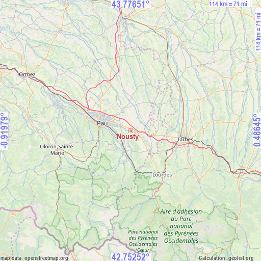
Nousty GPS coordinates[2]
43° 16' 0.012" North, 0° 13' 0.012" West
| Map corner | latitude | longitude |
|---|---|---|
| Upper-left | 43.77651°, | -0.91979° |
| Center: | 43.26667°, | -0.21667° |
| Lower-right: | 42.75252°, | 0.48645° |
| Map W x H: | 113.9×113.9 km | = 70.8×70.8mi |
| max Lat: | 51.07786° ⇑96.4% North |
| Nousty: | 43.26667° |
| min Lat: | ⇓3.6% South 41.3874° |
| min Long | Nousty | max Long |
| -5.08615° | -0.21667° | 9.52242° |
| W 20.1%⇐ | ⇒79.9% E |
Elevation
Elevation of Nousty is 266 m = 873 ft, and this is 72.3 m = 237 ft above average elevation for this country.
| Max E: |
2333 m = 7654 ft | 22.7% |
| Nousty | 266 m 873 ft | |
| Avg. | 193.7 m = 635 ft | |
Min E: |
-1 m = -3 ft | 77.3% |
See also: France elevation on elevation.city.
Geographical zone
Nousty is located in North temperate zone (between Tropic of Cancer and the Arctic Circle). Distance of this Northern Tropic circle is 2204.9 km =1370.1 mi to South.| Distance of | km | miles | from Nousty |
|---|---|---|---|
| North Pole | 5196.3 | 3228.8 | to North |
| Arctic Circle | 2590.4 | 1609.6 | to North |
| Tropic Cancer | 2204.9 | 1370.1 | to South |
| Equator | 4810.8 | 2989.3 | to South |


Nearby cities:
15 places around Nousty: (largest is in red/bold)
• Andoins
3.9 km =2.4 mi,  340°
340°
• Angaïs
4.6 km =2.9 mi,  216°
216°
• Artigueloutan
2.7 km =1.7 mi,  270°
270°
• Assat
7 km =4.3 mi,  254°
254°
• Beuste
5.7 km =3.5 mi,  193°
193°
• Boeil-Bezing
6.9 km =4.3 mi, 216°
• Bordes
6.5 km =4 mi,  235°
235°
• Bordères
7.4 km =4.6 mi,  180°
180°
• Bénéjacq
7.4 km =4.6 mi, 180°
• Espoey
4.5 km =2.8 mi,  114°
114°
• Lagos
5.6 km =3.5 mi, 180°
• Lée
5.7 km =3.5 mi,  288°
288°
• Ousse
4.5 km =2.8 mi, 294°
• Sendets
4.6 km =2.9 mi,  323°
323°
• Soumoulou
2.7 km =1.7 mi,  90°
90°
Sources, notices
• [Note1] Compared only with cities in France existing in our database
• [Src1] Map data: © OpenStreetMap contributors (CC-BY-SA)
• [Src2] Other city data from geonames.org with taken over terms of usage.
• [Src3] Geographical zone / Annual Mean Temperature by Robert A. Rohde @ Wikipedia
