Bordes geodata
Bordes (Nouvelle-Aquitaine) is a populated place; located in France in Europe/Paris (GMT+2) time zone. With population of 2,093 people, there are 4603 cities with bigger population in this country. Compared to other cities in France, 96.8% of cities are located further ↑North; 80.7% of cities are located further →East and 70.4% of cities have lower elevation than Bordes. Note1
Administrative division(s):
- Level 1: Nouvelle-Aquitaine
- Level 2: Département des Pyrénées-Atlantiques
- Level 3: Arrondissement de Pau
- Level 4: Bordes


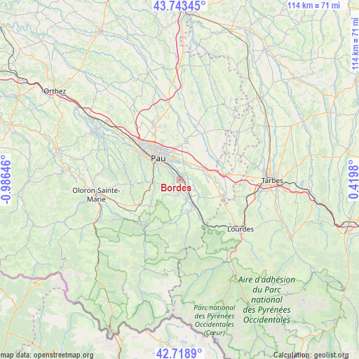
Bordes GPS coordinates[2]
43° 13' 59.988" North, 0° 16' 59.988" West
| Map corner | latitude | longitude |
|---|---|---|
| Upper-left | 43.74345°, | -0.98646° |
| Center: | 43.23333°, | -0.28333° |
| Lower-right: | 42.7189°, | 0.4198° |
| Map W x H: | 113.9×113.9 km | = 70.8×70.8mi |
| max Lat: | 51.07786° ⇑96.8% North |
| Bordes: | 43.23333° |
| min Lat: | ⇓3.2% South 41.3874° |
| min Long | Bordes | max Long |
| -5.08615° | -0.28333° | 9.52242° |
| W 19.3%⇐ | ⇒80.7% E |
Elevation
Elevation of Bordes is 221 m = 725 ft, and this is 27.3 m = 90 ft above average elevation for this country.
| Max E: |
2333 m = 7654 ft | 29.6% |
| Bordes | 221 m 725 ft | |
| Avg. | 193.7 m = 635 ft | |
Min E: |
-1 m = -3 ft | 70.4% |
See also: France elevation on elevation.city.
Geographical zone
Bordes is located in North temperate zone (between Tropic of Cancer and the Arctic Circle). Distance of this Northern Tropic circle is 2201.2 km =1367.8 mi to South.| Distance of | km | miles | from Bordes |
|---|---|---|---|
| North Pole | 5200 | 3231.1 | to North |
| Arctic Circle | 2594.1 | 1611.9 | to North |
| Tropic Cancer | 2201.2 | 1367.8 | to South |
| Equator | 4807.1 | 2987 | to South |


Nearby cities:
15 places around Bordes: (largest is in red/bold)
• Angaïs
2.7 km =1.7 mi,  90°
90°
• Arros-de-Nay
3.7 km =2.3 mi,  180°
180°
• Artigueloutan
4.6 km =2.9 mi,  36°
36°
• Assat
2.3 km =1.4 mi,  323°
323°
• Baudreix
3.8 km =2.4 mi,  147°
147°
• Beuste
4.5 km =2.8 mi,  114°
114°
• Boeil-Bezing
2.3 km =1.4 mi,  143°
143°
• Lagos
5.7 km =3.5 mi, 108°
• Lée
5.6 km =3.5 mi,  0°
0°
• Meillon
4.6 km =2.9 mi, 323°
• Narcastet
3.3 km =2.1 mi,  304°
304°
• Nay
5.7 km =3.5 mi,  166°
166°
• Ousse
5.7 km =3.5 mi,  13°
13°
• Rontignon
5.5 km =3.4 mi,  312°
312°
• Uzos
5.5 km =3.4 mi, 312°
Sources, notices
• [Note1] Compared only with cities in France existing in our database
• [Src1] Map data: © OpenStreetMap contributors (CC-BY-SA)
• [Src2] Other city data from geonames.org with taken over terms of usage.
• [Src3] Geographical zone / Annual Mean Temperature by Robert A. Rohde @ Wikipedia
