Niderviller geodata
Niderviller (Grand Est) is a populated place; located in France in Europe/Paris (GMT+2) time zone. With population of 1,119 people, there are 8016 cities with bigger population in this country. Compared to other cities in France, 73.5% of cities are located further ↓South; 95.3% of cities are located further ←West and 76.9% of cities have lower elevation than Niderviller. Note1
Administrative division(s):
- Level 1: Grand Est
- Level 2: Moselle
- Level 3: Arrondissement de Sarrebourg-Château-Salins
- Level 4: Niderviller


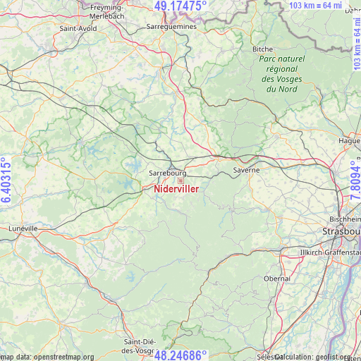
Niderviller GPS coordinates[2]
48° 42' 46.584" North, 7° 6' 22.572" East
| Map corner | latitude | longitude |
|---|---|---|
| Upper-left | 49.17475°, | 6.40315° |
| Center: | 48.71294°, | 7.10627° |
| Lower-right: | 48.24686°, | 7.8094° |
| Map W x H: | 103.2×103.2 km | = 64.1×64.1mi |
| max Lat: | 51.07786° ⇑26.5% North |
| Niderviller: | 48.71294° |
| min Lat: | ⇓73.5% South 41.3874° |
| min Long | Niderviller | max Long |
| -5.08615° | 7.10627° | 9.52242° |
| W 95.3%⇐ | ⇒4.7% E |
Elevation
Elevation of Niderviller is 263 m = 863 ft, and this is 69.3 m = 227 ft above average elevation for this country.
| Max E: |
2333 m = 7654 ft | 23.1% |
| Niderviller | 263 m 863 ft | |
| Avg. | 193.7 m = 635 ft | |
Min E: |
-1 m = -3 ft | 76.9% |
See also: France elevation on elevation.city.
Geographical zone
Niderviller is located in North temperate zone (between Tropic of Cancer and the Arctic Circle). Distance of this North polar circle is 1984.8 km =1233.3 mi to North.| Distance of | km | miles | from Niderviller |
|---|---|---|---|
| North Pole | 4590.7 | 2852.5 | to North |
| Arctic Circle | 1984.8 | 1233.3 | to North |
| Tropic Cancer | 2810.5 | 1746.4 | to South |
| Equator | 5416.4 | 3365.6 | to South |


Nearby cities:
15 places around Niderviller: (largest is in red/bold)
• Arzviller
4.4 km =2.7 mi,  82°
82°
• Brouderdorff
1.8 km =1.1 mi,  191°
191°
• Hartzviller
5.1 km =3.2 mi,  197°
197°
• Hesse
4.8 km =3 mi,  242°
242°
• Hilbesheim
7.1 km =4.4 mi,  355°
355°
• Hommarting
4 km =2.5 mi,  44°
44°
• Imling
6.1 km =3.8 mi,  276°
276°
• Lixheim
7.4 km =4.6 mi,  20°
20°
• Nitting
7.3 km =4.5 mi,  230°
230°
• Plaine-de-Walsch
2.6 km =1.6 mi,  164°
164°
• Réding
4.3 km =2.7 mi,  1°
1°
• Saint-Louis
6.1 km =3.8 mi,  86°
86°
• Sarraltroff
7.8 km =4.8 mi,  334°
334°
• Sarrebourg
4.4 km =2.7 mi,  304°
304°
• Walscheid
7.4 km =4.6 mi,  154°
154°
Sources, notices
• [Note1] Compared only with cities in France existing in our database
• [Src1] Map data: © OpenStreetMap contributors (CC-BY-SA)
• [Src2] Other city data from geonames.org with taken over terms of usage.
• [Src3] Geographical zone / Annual Mean Temperature by Robert A. Rohde @ Wikipedia
