Nalliers geodata
Nalliers (Pays de la Loire) is a populated place; located in France in Europe/Paris (GMT+2) time zone. With population of 2,012 people, there are 4770 cities with bigger population in this country. Compared to other cities in France, 60.4% of cities are located further ↑North; 88.4% of cities are located further →East and 98.6% of cities have higher elevation than Nalliers. Note1
Administrative division(s):
- Level 1: Pays de la Loire
- Level 2: Département de la Vendée
- Level 3: Arrondissement de Fontenay-le-Comte
- Level 4: Nalliers


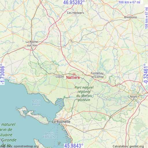
Nalliers GPS coordinates[2]
46° 28' 14.556" North, 1° 1' 39.864" West
| Map corner | latitude | longitude |
|---|---|---|
| Upper-left | 46.95282°, | -1.73086° |
| Center: | 46.47071°, | -1.02774° |
| Lower-right: | 45.9843°, | -0.32461° |
| Map W x H: | 107.7×107.7 km | = 66.9×66.9mi |
| max Lat: | 51.07786° ⇑60.4% North |
| Nalliers: | 46.47071° |
| min Lat: | ⇓39.6% South 41.3874° |
| min Long | Nalliers | max Long |
| -5.08615° | -1.02774° | 9.52242° |
| W 11.6%⇐ | ⇒88.4% E |
Elevation
Elevation of Nalliers is 7 m = 23 ft, and this is 186.7 m = 613 ft below average elevation for this country.
| Max E: |
2333 m = 7654 ft | 98.6% |
| Avg. | 193.7 m = 635 ft | |
| Nalliers | 7 m = 23 ft | |
Min E: |
-1 m = -3 ft | 1.4% |
See also: France elevation on elevation.city.
Geographical zone
Nalliers is located in North temperate zone (between Tropic of Cancer and the Arctic Circle). Distance of this North polar circle is 2234.1 km =1388.2 mi to North.| Distance of | km | miles | from Nalliers |
|---|---|---|---|
| North Pole | 4840 | 3007.4 | to North |
| Arctic Circle | 2234.1 | 1388.2 | to North |
| Tropic Cancer | 2561.1 | 1591.4 | to South |
| Equator | 5167.1 | 3210.7 | to South |


Nearby cities:
15 places around Nalliers: (largest is in red/bold)
• Chaillé-les-Marais
8.3 km =5.2 mi,  177°
177°
• Champagné-les-Marais
12.3 km =7.6 mi,  215°
215°
• Corpe
12.5 km =7.8 mi,  287°
287°
• Le Langon
7.1 km =4.4 mi,  120°
120°
• Le Poiré-sur-Velluire
12 km =7.5 mi, 122°
• Luçon
10.6 km =6.6 mi,  262°
262°
• Petosse
8.6 km =5.3 mi,  80°
80°
• Pouillé
7.2 km =4.5 mi,  56°
56°
• Puyravault
11.5 km =7.1 mi,  201°
201°
• Saint-Martin-sous-Mouzeuil
3.2 km =2 mi,  113°
113°
• Sainte-Gemme-la-Plaine
6.7 km =4.2 mi,  281°
281°
• Sainte-Hermine
9.7 km =6 mi,  347°
347°
• Sainte-Radégonde-des-Noyers
10.8 km =6.7 mi,  193°
193°
• Velluire
12.6 km =7.8 mi,  125°
125°
• Vouillé-les-Marais
10.4 km =6.5 mi,  151°
151°
Sources, notices
• [Note1] Compared only with cities in France existing in our database
• [Src1] Map data: © OpenStreetMap contributors (CC-BY-SA)
• [Src2] Other city data from geonames.org with taken over terms of usage.
• [Src3] Geographical zone / Annual Mean Temperature by Robert A. Rohde @ Wikipedia
