Luçon geodata
Luçon (Pays de la Loire) is a populated place; located in France in Europe/Paris (GMT+2) time zone. With population of 10,140 people, there are 935 cities with bigger population in this country. Compared to other cities in France, 60.5% of cities are located further ↑North; 89.7% of cities are located further →East and 98.2% of cities have higher elevation than Luçon. Note1
Administrative division(s):
- Level 1: Pays de la Loire
- Level 2: Département de la Vendée
- Level 3: Arrondissement de Fontenay-le-Comte
- Level 4: Luçon


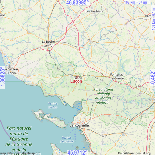
Luçon GPS coordinates[2]
46° 27' 27.828" North, 1° 9' 54.432" West
| Map corner | latitude | longitude |
|---|---|---|
| Upper-left | 46.93995°, | -1.86825° |
| Center: | 46.45773°, | -1.16512° |
| Lower-right: | 45.9712°, | -0.462° |
| Map W x H: | 107.7×107.7 km | = 66.9×66.9mi |
| max Lat: | 51.07786° ⇑60.5% North |
| Luçon: | 46.45773° |
| min Lat: | ⇓39.5% South 41.3874° |
| min Long | Luçon | max Long |
| -5.08615° | -1.16512° | 9.52242° |
| W 10.3%⇐ | ⇒89.7% E |
Elevation
Elevation of Luçon is 8 m = 26 ft, and this is 185.7 m = 609 ft below average elevation for this country.
| Max E: |
2333 m = 7654 ft | 98.2% |
| Avg. | 193.7 m = 635 ft | |
| Luçon | 8 m = 26 ft | |
Min E: |
-1 m = -3 ft | 1.8% |
See also: France elevation on elevation.city.
Geographical zone
Luçon is located in North temperate zone (between Tropic of Cancer and the Arctic Circle). Distance of this North polar circle is 2235.6 km =1389.1 mi to North.| Distance of | km | miles | from Luçon |
|---|---|---|---|
| North Pole | 4841.4 | 3008.3 | to North |
| Arctic Circle | 2235.6 | 1389.1 | to North |
| Tropic Cancer | 2559.7 | 1590.5 | to South |
| Equator | 5165.6 | 3209.8 | to South |


Nearby cities:
15 places around Luçon: (largest is in red/bold)
• Chaillé-les-Marais
12.8 km =8 mi,  122°
122°
• Champagné-les-Marais
9.2 km =5.7 mi,  158°
158°
• Chasnais
4.9 km =3 mi,  272°
272°
• Corpe
5.4 km =3.4 mi,  345°
345°
• Grues
12.5 km =7.8 mi,  238°
238°
• Lairoux
7.8 km =4.8 mi,  261°
261°
• Les Magnils-Reigniers
4.9 km =3 mi,  305°
305°
• Mareuil-sur-Lay-Dissais
9.9 km =6.2 mi,  328°
328°
• Moutiers-sur-le-Lay
10.8 km =6.7 mi,  2°
2°
• Nalliers
10.6 km =6.6 mi,  82°
82°
• Puyravault
11.2 km =7 mi,  145°
145°
• Péault
6.5 km =4 mi,  319°
319°
• Sainte-Gemme-la-Plaine
4.9 km =3 mi,  54°
54°
• Sainte-Radégonde-des-Noyers
12.1 km =7.5 mi,  138°
138°
• Triaize
7.7 km =4.8 mi,  199°
199°
Sources, notices
• [Note1] Compared only with cities in France existing in our database
• [Src1] Map data: © OpenStreetMap contributors (CC-BY-SA)
• [Src2] Other city data from geonames.org with taken over terms of usage.
• [Src3] Geographical zone / Annual Mean Temperature by Robert A. Rohde @ Wikipedia
