Maffliers geodata
Maffliers (Île-de-France) is a populated place; located in France in Europe/Paris (GMT+2) time zone. With population of 1,668 people, there are 5612 cities with bigger population in this country. Compared to other cities in France, 81.6% of cities are located further ↓South; 52.6% of cities are located further →East and 55.9% of cities have lower elevation than Maffliers. Note1
Administrative division(s):
- Level 1: Île-de-France
- Level 2: Département du Val-d’Oise
- Level 3: Arrondissement de Sarcelles
- Level 4: Maffliers


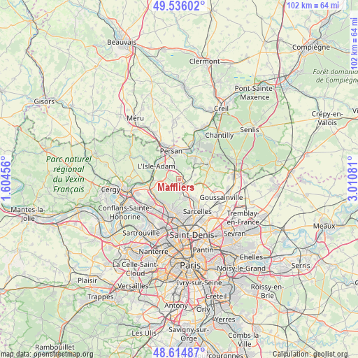
Maffliers GPS coordinates[2]
49° 4' 39.288" North, 2° 18' 27.648" East
| Map corner | latitude | longitude |
|---|---|---|
| Upper-left | 49.53602°, | 1.60456° |
| Center: | 49.07758°, | 2.30768° |
| Lower-right: | 48.61487°, | 3.01081° |
| Map W x H: | 102.4×102.4 km | = 63.6×63.6mi |
| max Lat: | 51.07786° ⇑18.4% North |
| Maffliers: | 49.07758° |
| min Lat: | ⇓81.6% South 41.3874° |
| min Long | Maffliers | max Long |
| -5.08615° | 2.30768° | 9.52242° |
| W 47.4%⇐ | ⇒52.6% E |
Elevation
Elevation of Maffliers is 153 m = 502 ft, and this is 40.7 m = 134 ft below average elevation for this country.
| Max E: |
2333 m = 7654 ft | 44.1% |
| Avg. | 193.7 m = 635 ft | |
| Maffliers | 153 m = 502 ft | |
Min E: |
-1 m = -3 ft | 55.9% |
See also: France elevation on elevation.city.
Geographical zone
Maffliers is located in North temperate zone (between Tropic of Cancer and the Arctic Circle). Distance of this North polar circle is 1944.3 km =1208.1 mi to North.| Distance of | km | miles | from Maffliers |
|---|---|---|---|
| North Pole | 4550.1 | 2827.3 | to North |
| Arctic Circle | 1944.3 | 1208.1 | to North |
| Tropic Cancer | 2851 | 1771.5 | to South |
| Equator | 5456.9 | 3390.8 | to South |


Nearby cities:
15 places around Maffliers: (largest is in red/bold)
• Attainville
3.5 km =2.2 mi,  129°
129°
• Baillet-en-France
1.9 km =1.2 mi,  200°
200°
• Belloy-en-France
4.8 km =3 mi,  75°
75°
• Bouffémont
3.8 km =2.4 mi,  190°
190°
• Domont
5.7 km =3.5 mi,  166°
166°
• L’Isle-Adam
6.7 km =4.2 mi,  299°
299°
• Moisselles
3.7 km =2.3 mi,  146°
146°
• Montsoult
1.3 km =0.8 mi,  136°
136°
• Mours
6.6 km =4.1 mi,  333°
333°
• Nerville-la-Forêt
2.4 km =1.5 mi,  307°
307°
• Nointel
5.8 km =3.6 mi,  347°
347°
• Noisy-sur-Oise
6.8 km =4.2 mi,  14°
14°
• Saint-Martin-du-Tertre
4.3 km =2.7 mi,  39°
39°
• Villaines-sous-Bois
3.7 km =2.3 mi,  92°
92°
• Villiers-Adam
5.5 km =3.4 mi,  254°
254°
Sources, notices
• [Note1] Compared only with cities in France existing in our database
• [Src1] Map data: © OpenStreetMap contributors (CC-BY-SA)
• [Src2] Other city data from geonames.org with taken over terms of usage.
• [Src3] Geographical zone / Annual Mean Temperature by Robert A. Rohde @ Wikipedia
