Domont geodata
Domont (Île-de-France) is a populated place; located in France in Europe/Paris (GMT+2) time zone. With population of 16,684 people, there are 570 cities with bigger population in this country. Compared to other cities in France, 80.4% of cities are located further ↓South; 52.2% of cities are located further →East and 51.7% of cities have lower elevation than Domont. Note1
Administrative division(s):
- Level 1: Île-de-France
- Level 2: Département du Val-d’Oise
- Level 3: Arrondissement de Sarcelles
- Level 4: Domont


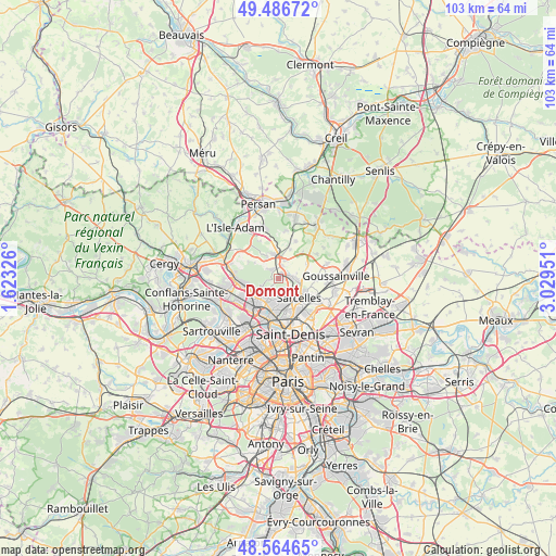
Domont GPS coordinates[2]
49° 1' 40.152" North, 2° 19' 34.968" East
| Map corner | latitude | longitude |
|---|---|---|
| Upper-left | 49.48672°, | 1.62326° |
| Center: | 49.02782°, | 2.32638° |
| Lower-right: | 48.56465°, | 3.02951° |
| Map W x H: | 102.5×102.5 km | = 63.7×63.7mi |
| max Lat: | 51.07786° ⇑19.6% North |
| Domont: | 49.02782° |
| min Lat: | ⇓80.4% South 41.3874° |
| min Long | Domont | max Long |
| -5.08615° | 2.32638° | 9.52242° |
| W 47.8%⇐ | ⇒52.2% E |
Elevation
Elevation of Domont is 138 m = 453 ft, and this is 55.7 m = 183 ft below average elevation for this country.
| Max E: |
2333 m = 7654 ft | 48.3% |
| Avg. | 193.7 m = 635 ft | |
| Domont | 138 m = 453 ft | |
Min E: |
-1 m = -3 ft | 51.7% |
See also: France elevation on elevation.city.
Geographical zone
Domont is located in North temperate zone (between Tropic of Cancer and the Arctic Circle). Distance of this North polar circle is 1949.8 km =1211.5 mi to North.| Distance of | km | miles | from Domont |
|---|---|---|---|
| North Pole | 4555.7 | 2830.8 | to North |
| Arctic Circle | 1949.8 | 1211.5 | to North |
| Tropic Cancer | 2845.5 | 1768.1 | to South |
| Equator | 5451.4 | 3387.3 | to South |


Nearby cities:
15 places around Domont: (largest is in red/bold)
• Andilly
2.7 km =1.7 mi,  220°
220°
• Attainville
3.6 km =2.2 mi,  22°
22°
• Baillet-en-France
4.3 km =2.7 mi,  332°
332°
• Bouffémont
2.7 km =1.7 mi,  310°
310°
• Eaubonne
4.7 km =2.9 mi, 223°
• Margency
3.6 km =2.2 mi,  211°
211°
• Moisselles
2.6 km =1.6 mi, 15°
• Montlignon
3.7 km =2.3 mi,  230°
230°
• Montmorency
4.6 km =2.9 mi,  164°
164°
• Montsoult
4.7 km =2.9 mi,  353°
353°
• Piscop
2.2 km =1.4 mi,  141°
141°
• Saint-Brice-sous-Forêt
3.6 km =2.2 mi,  146°
146°
• Saint-Prix
4.5 km =2.8 mi,  254°
254°
• Écouen
4.2 km =2.6 mi,  100°
100°
• Ézanville
3 km =1.9 mi,  89°
89°
Sources, notices
• [Note1] Compared only with cities in France existing in our database
• [Src1] Map data: © OpenStreetMap contributors (CC-BY-SA)
• [Src2] Other city data from geonames.org with taken over terms of usage.
• [Src3] Geographical zone / Annual Mean Temperature by Robert A. Rohde @ Wikipedia
