Luzenac geodata
Luzenac (Occitanie) is a populated place; located in France in Europe/Paris (GMT+2) time zone. With population of 669 people, there are 12229 cities with bigger population in this country. Compared to other cities in France, 98.9% of cities are located further ↑North; 59.9% of cities are located further →East and 95.2% of cities have lower elevation than Luzenac. Note1
Administrative division(s):
- Level 1: Occitanie
- Level 2: Département de l'Ariège
- Level 3: Arrondissement de Foix
- Level 4: Luzenac


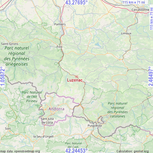
Luzenac GPS coordinates[2]
42° 45' 46.404" North, 1° 45' 42.624" East
| Map corner | latitude | longitude |
|---|---|---|
| Upper-left | 43.27695°, | 1.05872° |
| Center: | 42.76289°, | 1.76184° |
| Lower-right: | 42.24453°, | 2.46497° |
| Map W x H: | 114.8×114.8 km | = 71.3×71.3mi |
| max Lat: | 51.07786° ⇑98.9% North |
| Luzenac: | 42.76289° |
| min Lat: | ⇓1.1% South 41.3874° |
| min Long | Luzenac | max Long |
| -5.08615° | 1.76184° | 9.52242° |
| W 40.1%⇐ | ⇒59.9% E |
Elevation
Elevation of Luzenac is 598 m = 1962 ft, and this is 404.3 m = 1326 ft above average elevation for this country.
| Max E: |
2333 m = 7654 ft | 4.8% |
| Luzenac | 598 m 1962 ft | |
| Avg. | 193.7 m = 635 ft | |
Min E: |
-1 m = -3 ft | 95.2% |
See also: France elevation on elevation.city.
Geographical zone
Luzenac is located in North temperate zone (between Tropic of Cancer and the Arctic Circle). Distance of this Northern Tropic circle is 2148.9 km =1335.3 mi to South.| Distance of | km | miles | from Luzenac |
|---|---|---|---|
| North Pole | 5252.3 | 3263.6 | to North |
| Arctic Circle | 2646.4 | 1644.4 | to North |
| Tropic Cancer | 2148.9 | 1335.3 | to South |
| Equator | 4754.8 | 2954.5 | to South |


Nearby cities:
15 places around Luzenac: (largest is in red/bold)
• Arignac
17.7 km =11 mi,  311°
311°
• Auzat
22.9 km =14.2 mi,  270°
270°
• Ax-les-Thermes
7.9 km =4.9 mi,  127°
127°
• Bélesta
20.9 km =13 mi,  42°
42°
• Ferrières-sur-Ariège
23.1 km =14.4 mi,  328°
328°
• Fougax-et-Barrineuf
17.1 km =10.6 mi, 39°
• Lavelanet
20 km =12.4 mi,  20°
20°
• Mercus-Garrabet
16.8 km =10.4 mi,  319°
319°
• Montferrier
14.6 km =9.1 mi,  8°
8°
• Montgaillard
21.7 km =13.5 mi, 331°
• Saint-Paul-de-Jarrat
19 km =11.8 mi, 332°
• Saurat
22.3 km =13.9 mi, 305°
• Tarascon-sur-Ariège
15.9 km =9.9 mi, 305°
• Vicdessos
21.8 km =13.5 mi, 271°
• Villeneuve-d’Olmes
16.6 km =10.3 mi, 16°
Sources, notices
• [Note1] Compared only with cities in France existing in our database
• [Src1] Map data: © OpenStreetMap contributors (CC-BY-SA)
• [Src2] Other city data from geonames.org with taken over terms of usage.
• [Src3] Geographical zone / Annual Mean Temperature by Robert A. Rohde @ Wikipedia
