Louches geodata
Louches (Hauts-de-France) is a populated place; located in France in Europe/Paris (GMT+2) time zone. With population of 755 people, there are 11114 cities with bigger population in this country. Compared to other cities in France, 99.4% of cities are located further ↓South; 57.1% of cities are located further →East and 89.5% of cities have higher elevation than Louches. Note1
Administrative division(s):
- Level 1: Hauts-de-France
- Level 2: Pas-de-Calais
- Level 3: Arrondissement de Calais
- Level 4: Louches


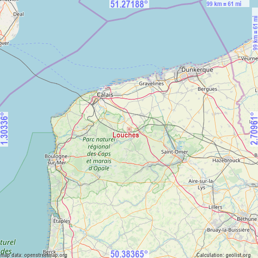
Louches GPS coordinates[2]
50° 49' 47.568" North, 2° 0' 23.328" East
| Map corner | latitude | longitude |
|---|---|---|
| Upper-left | 51.27188°, | 1.30336° |
| Center: | 50.82988°, | 2.00648° |
| Lower-right: | 50.38365°, | 2.70961° |
| Map W x H: | 98.8×98.8 km | = 61.4×61.4mi |
| max Lat: | 51.07786° ⇑0.6% North |
| Louches: | 50.82988° |
| min Lat: | ⇓99.4% South 41.3874° |
| min Long | Louches | max Long |
| -5.08615° | 2.00648° | 9.52242° |
| W 42.9%⇐ | ⇒57.1% E |
Elevation
Elevation of Louches is 31 m = 102 ft, and this is 162.7 m = 534 ft below average elevation for this country.
| Max E: |
2333 m = 7654 ft | 89.5% |
| Avg. | 193.7 m = 635 ft | |
| Louches | 31 m = 102 ft | |
Min E: |
-1 m = -3 ft | 10.5% |
See also: France elevation on elevation.city.
Geographical zone
Louches is located in North temperate zone (between Tropic of Cancer and the Arctic Circle). Distance of this North polar circle is 1749.4 km =1087 mi to North.| Distance of | km | miles | from Louches |
|---|---|---|---|
| North Pole | 4355.3 | 2706.3 | to North |
| Arctic Circle | 1749.4 | 1087 | to North |
| Tropic Cancer | 3045.8 | 1892.6 | to South |
| Equator | 5651.8 | 3511.9 | to South |


Nearby cities:
15 places around Louches: (largest is in red/bold)
• Andres
7.2 km =4.5 mi,  303°
303°
• Ardres
3.6 km =2.2 mi,  330°
330°
• Audruicq
7.4 km =4.6 mi,  43°
43°
• Balinghem
5.6 km =3.5 mi,  307°
307°
• Bonningues-lès-Ardres
4.2 km =2.6 mi,  171°
171°
• Bouquehault
7.3 km =4.5 mi,  266°
266°
• Brêmes
3.5 km =2.2 mi,  323°
323°
• Landrethun-lès-Ardres
3.3 km =2.1 mi,  261°
261°
• Licques
7 km =4.3 mi,  223°
223°
• Nordausques
5.4 km =3.4 mi,  103°
103°
• Nortkerque
5.2 km =3.2 mi,  14°
14°
• Polincove
6.2 km =3.9 mi,  71°
71°
• Recques-sur-Hem
5.7 km =3.5 mi,  85°
85°
• Tournehem-sur-la-Hem
4.5 km =2.8 mi,  137°
137°
• Zutkerque
5 km =3.1 mi,  59°
59°
Sources, notices
• [Note1] Compared only with cities in France existing in our database
• [Src1] Map data: © OpenStreetMap contributors (CC-BY-SA)
• [Src2] Other city data from geonames.org with taken over terms of usage.
• [Src3] Geographical zone / Annual Mean Temperature by Robert A. Rohde @ Wikipedia
